Places near here
Photo credits
- National Inventory of Architectural Heritage
- Ben Brooksbank, Geograph · CC BY-SA 2.0
- MPF, Wikimedia Commons · CC BY-SA 3.0
- Kenneth Allen, Geograph · CC BY-SA 2.0
- Rossographer, Geograph · CC BY-SA 2.0
- Michal Osmenda from Brussels, Belgium, Wikimedia Commons · CC BY-SA 2.0
- Andreas F. Borchert, Wikimedia Commons · CC BY-SA 4.0
- Ronnie Nijboer, Wikimedia Commons · CC0
- Shane Killen, Geograph · CC BY-SA 2.0
- Kieran Evans, Wikimedia Commons · CC BY-SA 4.0
- Patrice78500, Wikimedia Commons · CC BY-SA 3.0
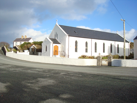 Saint Mary's Catholic ChurchChurch/chapel · 802 yd
Explorer Tom Saint Mary's Catholic Church in Fanavolty was built around 1830 with an unusual five-sided apse. I tried to draw it as a plain rectangle in my head, and the east end made my pencil turn five times. That is a useful surprise.
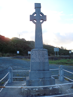 Fanad Patriots MonumentMonument · 1524 yd
Explorer Tom Fanad Patriots Monument is a limestone Celtic cross erected in 1960 above Kindrum Lough. Its inscription praises three men for what happened at Cratlagh Wood in 1878; the heritage record identifies this as Lord Leitrim’s assassination. I would pause over both descriptions before calling the history settled.
 Lighthouse TavernPub · 3.0 mi
Explorer Tom Lighthouse Tavern closes every Thursday, which makes it perfect for mysterious disappearances and unexplained puddles. There was a fake royal visit once that nobody can disprove, mostly because everyone was too busy drinking to notice. Perfect detour when the satnav has a meltdown.
 Hazel3.3 mi
Explorer Tom Hazel in County Donegal has a long list of former names because every farmer who passed by thought they could do a better job naming it. It’s got that identity crisis energy where it just shrugs and lets them call it whatever they want. Bring a camera and your most suspicious face.
 Moross CastleCastle, tower house · 3.4 mi
Explorer Tom Moross Castle was built in 1532 and sits on a tiny rocky island connected by a causeway. By 1622, someone had slapped a thatched roof on the ruins while it lay waste, which is peak medieval DIY. Only the southwest corner survives now, but that narrow causeway makes it feel like you’re walking onto a very defensive boat.
 Fanad Head Lighthouse Visitor CentreVisitor information · 3.4 mi
Explorer Tom Fanad Head Lighthouse Visitor Centre is where the lighthouse keeper got so annoyed at the fox stealing his lunch that he appointed it the new head warden. Now the fox runs the show and only lets you in if you bring premium sardines. Spot the oldest stone and give it a name before the fox changes its mind.
.jpg/250px-Fanad_Head_(2698646541).jpg "Photo: Michal Osmenda from Brussels, Belgium, Wikimedia Commons · CC BY-SA 2.0") Fanad HeadCoast · 3.5 mi
Fanad HeadCoast · 3.5 miExplorer Tom Fanad Head is the tip of the peninsula between Lough Swilly and Mulroy Bay. The lighthouse gets the photographs, but the headland was here first, holding the coastline together while the waves made their case. I would give the cliffs their space and look from a safe point.
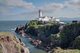 Fanad Head LighthouseLighthouse · 3.5 mi
Explorer Tom Fanad Head Lighthouse has 76 steps between you and the tower view. The guides tell what life was like for the keeper families who looked after this light. I reckon their stories are worth hearing before anyone starts bragging about the climb.
 Wych Elm3.9 mi
Explorer Tom Wych Elm in Donegal is the site of a fierce fairy dispute over parking rights, as they argue about who gets the best branch view under its sprawling canopy. It’s a sturdy tree that has seen more seasons than you have teeth, standing firm while the small folk throw their tantrums below. Bring sandwiches, the gulls will thank you.
 Trá na Rosann HostelHostel · 4.2 mi
Explorer Tom Trá na Rosann Hostel sits on the Rosguill Peninsula, claiming to be Ireland's most northerly bed. It’s basically a hunting lodge pretending to be fancy while you stare into the void. Take a mate and argue about what it was for.
 The Murder HoleCave · 4.2 mi
Explorer Tom The Murder Hole would cope perfectly on a reality show by hiding in the corner and pretending the camera crew wasn’t there. It thinks its dark reputation is just great marketing and refuses to do any actual work or make eye contact with anyone. Spot the oldest stone and give it a silly name, because that’s what you should do.
 Cnoc na SleáMountain / peak · 4.2 mi
Explorer Tom Cnoc na Sleá means 'hill of the spear', though I would leave any spear firmly in the name. The guide also calls this small Donegal hill Crocknasleigh and points out its older Irish spelling. One hill, two ways to say it, and a very pointed name.
More islands in County Donegal · All of County Donegal

What do you know about this place?Tap to add a comment or ask a question