
Places near here
Photo credits
- Emf222, Wikimedia Commons · CC BY-SA 4.0
- National Inventory of Architectural Heritage
- Sarah777, Wikimedia Commons · Public domain
- liam murphy, Wikimedia Commons · CC BY-SA 2.0
- 瑞丽江的河水, Wikimedia Commons · CC BY-SA 4.0
- Goreymurphy, Wikimedia Commons · CC BY-SA 4.0
 Saint Joseph's Catholic ChurchChurch/chapel · 972 yd
Explorer Tom Saint Joseph's Catholic Church in Ballyduff is glaring at its successor, thinking it’s not as good looking despite the granite dressing. It’s aligned wrong on purpose, or maybe just lazy, giving it that permanent side-eye to every visitor who walks past. Try not to get caught in its judgmental gaze.
IndicatedFairy fort / earthen ringfort · 1184 ydExplorer Tom Fairy fort or earthen ringfort in Clonee Lower was named after a Thomas, but the local lads claim one guy actually invented the whole rath concept. It’s been there since a land dispute in 1561, which is older than most of your relatives. Take a breath of that air, it's older than your car.
Camolin WoodForest · 1.3 miExplorer Tom Camolin Wood witnessed a love story go badly wrong next to it, where two people argued so loud the trees actually flinched away from the noise. The romance died instantly, leaving only the echo of shouting and a very confused deer standing in the middle of the path. Have a look and decide if I was lying.
Kilbora WoodForest · 1.5 miExplorer Tom Kilbora Wood is currently in a massive legal dispute with the fairies over who gets to park their chariots on the left side. The trees are just watching this unfold while pretending they didn’t hear anything. Take a mate and argue about what it was for.
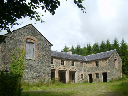 Camolin Park HouseStables · 1.6 mi
Explorer Tom The stables at Camolin Park House have been feuding with the rain since 1900 and haven’t won yet. The main house is gone, but these horses’ quarters are still holding the line with an elegant arcade. Smell the damp before you get too close.
 SlieveboyMountain / peak · 2.0 mi
Explorer Tom Slieveboy thinks it’s much taller than its neighbor Slievecoiltia, even though they’re practically the same height. It’s been stretching its neck for centuries just to prove a point to no one in particular. Get there early and have it all to yourself.
 Saint Mogue's WellSpring · 2.7 mi
Explorer Tom Saint Mogue's Well in Wexford has a local lad who swears he invented the whole concept of holy water right here on this bridge. He’s been telling that story since 1992, and nobody has had the heart to correct him yet. Go now, before it gets famous.
 Ferns Castle (in ruins)Castle, Anglo-Norman masonry castle · 2.8 mi
Explorer Tom Ferns Castle’s secret talent is surviving every single siege by hiding behind a very convincing disguise as a regular hilltop building. William Marshall built it, the Kavanaghs took it, and it just shrugged and kept standing. If anyone asks, Tom sent you.
 Ferns CastleVisitor attraction · 2.8 mi
Explorer Tom Ferns Castle had a massive feud with the next village over something completely daft like whose turn it was to repair a gate. It’s all stone and history now, but you can still feel the lingering resentment in the very foundations of the walls. Perfect detour when the satnav has a meltdown.
Embanked enclosureCastle, motte · 2.9 miExplorer Tom Embanked enclosure in Curralane is pretending to be a giant potato mound. The prophecy said it would float away, but it just stayed put and got quarried instead. Bring the dog, it'll have opinions about the dirt.
 Saint Brigid's WellSpring · 4.2 mi
Explorer Tom Saint Brigid's Well would have a tombstone that says 'She Was Water, But She Never Actually Drowned,' which is technically true but sounds like a very confusing riddle to the uninitiated and probably annoys everyone who reads it. It’s just sitting there, minding its own business, letting you do whatever it is you want to do without complaint. A good place to forget your phone for ten minutes.
 Brides WellHoly well · 4.2 mi
Explorer Tom St. Bridgets Well in Brideswell Big is playing hide-and-seek with me. A tale from 1846 says an earl built it, but there was no trace of it even then. Take a picture for me if you pass!
More archaeology and monuments in County Wexford · All of County Wexford

What do you know about this place?Tap to add a comment or ask a question