
Places near here
Photo credits
- Balloholic (talk), Wikimedia Commons
- National Inventory of Architectural Heritage
- Maker not stated on source page, www.pinterest.com
- Andreas F. Borchert, Wikimedia Commons · CC BY-SA 4.0
- Maker not stated on source page, www.tripadvisor.ie
- Ian S, Geograph · CC BY-SA 2.0
- MaxPride, Wikimedia Commons
- Maker not stated on source page, www.tripadvisor.ru
- Kenneth Allen, Wikimedia Commons · CC BY-SA 2.0
 Ballymacool ParkPark · 449 yd
Explorer Tom Ballymacool Park sits just outside Letterkenny with the excellent confidence of a place that knows a good hill, a broad…
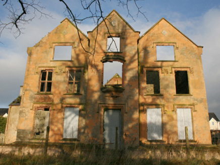 Ballymacool HouseCountry house · 555 yd
Explorer Tom Ballymacool House is a dramatic ruin now, but back in the c. 1770s it was the sort of grand home where John Boyd bought…
 Conwal Old GraveyardGraveyard · 873 yd
Explorer Tom Conwal Old Graveyard sees its grassy mound turned into a perfectly rectangular stone cairn around 1968. It is…
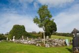 Conwal Old ChurchChurch · 952 yd
Explorer Tom Conwal Old Church was already described as ruinous in 1622. The survey says a central ivy-covered section of the south…
 Conwal Old Church Grave-slab CairnMound · 954 yd
Explorer Tom Conwal Old Church Grave-slab Cairn sits right inside an active graveyard on the slopes of Glendoon Hill. In 1968…
 Conwal Wheeled Cross SlabCross-slab · 954 yd
Explorer Tom Conwal Wheeled Cross Slab is a tiny, battered fragment that survived the mess of a 1968 tidy-up. It’s just the top half…
 Godfrey O'Donnell GraveslabGraveslab · 954 yd
Explorer Tom Godfrey O'Donnell Graveslab claims to be the final resting spot of a guy who died in 1258. It’s got a wheeled-cross…
 Rockhill HouseGates/railings/walls · 957 yd
Explorer Tom Rockhill House is the name attached to its main gateway: two painted piers between curved stone walls. It may date from…
 Tir na NogPub · 1118 yd
Explorer Tom Tir na Nog sounds like a name invented by someone who had one too many pints. Bet they’ve got a special named after a…
 O’Donnell ParkGAA ground · 1265 yd
Explorer Tom O’Donnell Park belongs to St Eunan’s in Letterkenny, and in 2026 Donegal chose it for a senior county championship…
 The Church Restaurant and BarRestaurant · 1542 yd
Explorer Tom The Church Restaurant and Bar in Letterkenny is having a nap because it’s closed on Mondays and Tuesdays. I bet the…
 Battlefield in Ardahee,ballyconnelly (ballymacool Ed),bomany,doon GlebeBattlefield · 1.1 mi
Explorer Tom Battlefield in Ardahee in Donegal gets picked on by the wind because it refuses to admit who actually won that fight…
More archaeology and monuments in County Donegal · All of County Donegal

What do you know about this place?Tap to add a comment or ask a question