
What is recorded here
From OpenStreetMap (© OpenStreetMap contributors) n11765909485
Places near here
Picture notes
- Computer-made picture. It does not show this monument.
- Computer-made picture. It does not show this mountain top.
- National Inventory of Architectural Heritage
- Computer-made picture. It does not show this playground.
- Coleman Photographic Collection; photographer unknown, Wikimedia Commons · Public domain
- Oliver Dixon, Geograph · CC BY-SA 2.0
- Computer-made picture. It does not show this walking route.
- Ian Rob, Wikimedia Commons · CC BY-SA 2.0
- Eric Jones, Geograph · CC BY-SA 2.0
 Fairy fort / earthen ringfort in DerryhumFairy fort / earthen ringfort · 259 ydComputer-made picture
Explorer Tom Fairy fort / earthen ringfort in Derryhum is low-key and has lost most of its bank to modern field boundaries. It’s like wearing a trench coat over nothing. Have a chat with it, nobody's watching.
 Fairy fort / earthen ringfort in GreaghadooFairy fort / earthen ringfort · 1206 ydComputer-made picture
Explorer Tom Overgrown with trees and bushes inside, this Greaghadoo fort features a deep fosse partly filled with field-clearance debris.
 TermonMountain / peak · 1542 ydComputer-made picture
Explorer Tom Termon is a peaceful peak in County Cavan, a place where the wind seems to slow down and time stands still for a moment.
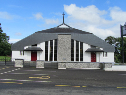 St Mary’s Roman Catholic ChurchChurch/chapel · 1.1 mi
Explorer Tom St Mary’s Roman Catholic Church in Termon is a modern style church that replaced three previous ones because people couldn’t agree on a roof. It’s got a belfry from 1883 and looks like it’s trying to be cool. The one question it’s sick of being asked? 'Is this the new one?' Yes, it is.
 GreaghnafarnaMountain / peak · 1.3 miComputer-made picture
Explorer Tom Greaghnafarna sits in County Cavan, a mountain whose details are confined to its location and linked names on the map.
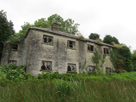 Lismagiril Church of Ireland SchoolSchool · 1.6 mi
Explorer Tom Lismagiril Church of Ireland School has an off-centre chimney that looks permanently confused. It’s a Farnham family pattern design, which basically means it was built by committee and never agreed on where to put the smoke. Send me a selfie next to that lopsided stack!
 Children's playground2.7 miComputer-made picture
Explorer Tom This Children's playground in County Cavan likely holds secrets about which slide produces the best shriek of pure, unadulterated delight.
 Bailieborough CastleCastle, unclassified · 4.6 mi
Explorer Tom Bailieborough Castle was built by William Baillie on top of an ancient fort called Tonregie, which sounds like a sneeze. Stand still and listen, the wind tells it better than me.
 Brothers GravesVisitor information · 4.6 mi
Explorer Tom Brothers Graves holds a touching memory, marking seven Marist brothers who lived long lives in this community.
 Bailieborough Castle Lake Loop (PJ's Way)Walking route · 5.0 miComputer-made picture
Explorer Tom Bailieborough Castle Lake Loop (PJ's Way) is a walking route that likely loops right back to where you started.
.jpg/250px-Ballyjamesduff-Cavan_County_Museum_(geograph_7350383).jpg "Photo: Ian Rob, Wikimedia Commons · CC BY-SA 2.0") Cavan County MuseumMuseum · 5.3 mi
Cavan County MuseumMuseum · 5.3 miExplorer Tom The Cavan County Museum in Ballyjamesduff is an excellent place to delve into the local history of County Cavan.
 Cormeen Glebe ForestForest · 5.7 mi
Explorer Tom Cormeen Glebe Forest near Clifferna, County Cavan, feels like a peaceful retreat; perhaps a farmhouse ghost is waving from the trees.
More mountains and hills in County Cavan · All of County Cavan

What do you know about this place?Tap to add a comment or ask a question