
What is recorded here
From OpenStreetMap (© OpenStreetMap contributors) n9816928868
Places near here
Photo credits
- National Inventory of Architectural Heritage
- Mike Searle, Wikimedia Commons · CC BY-SA 2.0
- Richard Fensome, Wikimedia Commons · CC BY-SA 2.0
- A.-K. D., Wikimedia Commons · CC BY-SA 4.0
- Alison Cassidy, Wikimedia Commons · CC BY-SA 4.0
- Gordon Hatton, Wikimedia Commons · CC BY-SA 2.0
- El Gringo ( talk ) ( Uploads ), Wikimedia Commons · CC BY-SA 3.0
 Séipéal Naomh Lachtáin [Saint Lachteen's Catholic Church]Church/chapel · 2.0 mi
Explorer Tom Séipéal Naomh Lachtáin is standing proud like it owns the whole hill. It’s got that classic 'we are very important here' vibe that churches love to project on their neighbours. If Saint Patrick saw this, he’d probably just shrug and say, "Yeah, about time."
Port Ban Nature Reserve, Irish Wildlife TrustNature reserve · 2.3 mi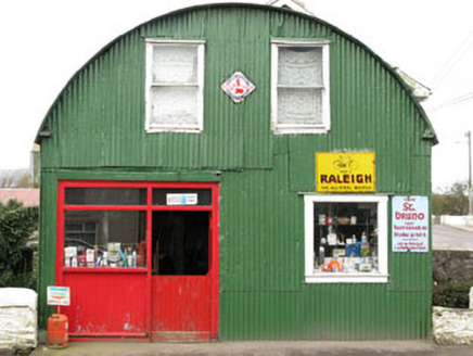 shop/retail outlet2.7 mi
Explorer Tom Shop or retail outlet in Inchigeelagh is made entirely of iron and sitting on top of a stream, which sounds risky if the weather turns. It's the only one like it in town, so don't let it rust out completely. Wave from a safe distance!
European long distance path E8 - part IrelandWalking route · 2.7 mi Carrignacurra CastleCastle · 3.1 mi
Explorer Tom Carrignacurra Castle in County Cork was the chief seat of the O'Learys. Built on a rock by the River Lee! It got captured and forfeited. Take a picture for me if you see the history peeking through!
 Carrignacurra Castle (in Ruins)Castle, tower house · 3.1 mi
Explorer Tom Carrignacurra Castle sits on a rock outcrop close to the River Lee. Its secret talent is holding up its own ivy-clad corners without complaining. It's the kind of place that makes a dull Tuesday interesting.
Sli Gaeltacht MuscraiWalking route · 3.4 mi CairnCairn, unclassified · 4.3 mi
Explorer Tom St Abbán’s grave at An Tseanchluain is guarding some ogham stones like a grumpy gatekeeper. It’s got a bullaun on top for good luck, or bad luck if you spill tea. Bring sandwiches, and the gulls will probably thank you, or steal them.
Kealaboane WoodWood · 4.4 mi St Gobnets WellHoly well · 4.5 mi
Explorer Tom St Gobnets Well is the final stop on a pilgrimage, which sounds exhausting for everyone involved. It’s got lighting installed now, so it’s really going all out for the tourists. Walk past slowly like you're in a film.
 Kilmichael Ambush SiteMonument · 6.2 mi
 Kilmichael AmbushAmbush · 6.2 mi
Explorer Tom Kilmichael Ambush in County Cork is where the rabbits think the soldiers were just having a very aggressive game of hide-and-seek. Pretend you're a lost aristocrat, nobody will check your ID.
More mountains and hills in County Cork · All of County Cork

What do you know about this place?Tap to add a comment or ask a question