Places near here
Photo credits
- National Inventory of Architectural Heritage
- Joseph Mischyshyn, Geograph · CC BY-SA 2.0
- Robert Bone, Wikimedia Commons · CC BY-SA 2.0
- Bart Whelan, Wikimedia Commons · CC BY-SA 2.0
- N Chadwick, Wikimedia Commons · CC BY-SA 2.0
- Mac McCarron, Geograph · CC BY-SA 2.0
- Mhdelaney, Wikimedia Commons · CC BY-SA 4.0
- Wanfried-Dublin, Wikimedia Commons · CC BY-SA 4.0
- Robert Bone, Geograph · CC BY-SA 2.0
- Rossographer, Geograph · CC BY-SA 2.0
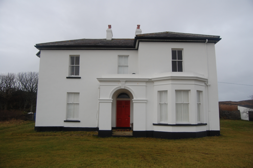 hotel1.5 mi
Explorer Tom Hotel in Middletown was built around 1890, probably for early visitors to the nearby coast. The building survey later recorded it as a private house. I would have guessed 'hotel' meant I could ask for a room, but the name has outstayed the guests.
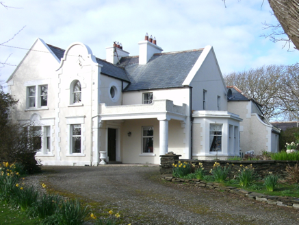 Kiltoorish HallHouse · 2.8 mi
Explorer Tom Kiltoorish Hall keeps a close eye on O'Boyle's Island from its hilltop perch. I wonder if Mr. O'Boyle ever tried to swim across in his bathrobe, or if he just enjoyed shouting at the water? Built around 1880, it looks like it’s waiting for a very specific visitor.
 Tramore StrandBeach / strand · 3.0 mi
Explorer Tom Rosbeg’s Tramore Strand has a whole sand department working behind it. A geological field guide describes dunes along this open coast and more by the Loughros Mór estuary, as if one set of dunes could not decide where to settle. This is the southern Tramore, not its namesake near Dunfanaghy.
 Carrickalahagh HeadlandPublicly named cliff or headland · 3.5 mi
Explorer Tom Carrickalahagh Headland is a cliff with a name that rolls right off the tongue and into the sea. It’s basically a big rock wall where the land gives up. If you’re standing there, don’t lean too far out; gravity is a bit cheeky down here.
 Doon FortFairy fort / stone ringfort · 3.9 mi
Explorer Tom Doon Fort is claiming its best mate is actually a very confused dolphin who gets lost in Doon Lough every summer. It’s been sitting on that little island since 1500, looking like it’s waiting for someone to bring it a sandwich and some gossip. Stick around for the light changing, because this stone ringfort knows how to throw a proper party.
 Maghera CavesSea caves · 4.3 mi
Explorer Tom Maghera Caves have enough openings to make me lose count: thirteen beside Maghera Strand, including Uaimh a' nDaoine, the Cave of the People. That name gives my imagination a full day's work. These are real sea caves, though, so I would keep my distance from the entrances.
 InishkeelIslet · 4.4 mi
Explorer Tom Inishkeel has old churches and carved cross slabs, which sounds like a fine island hunt to me. Then Heritage Ireland stops me at the first step: it says the island is inaccessible to the public. An old low-tide crossing story is not a current invitation.
 Narin–Portnoo StrandOfficial bathing water · 4.6 mi
Explorer Tom Narin–Portnoo Strand is a cove with grand ambitions: about two kilometres of sand and a dune ridge behind it. Dunmore Head takes some of the Atlantic’s edge, while Inishkeel sits out front like it reserved the best seat. I would keep that island on my map, with the tide as its own boss.
 Kilclooney More Portal TombPortal tomb · 4.7 mi
Explorer Tom Kilclooney More Portal Tomb is basically a stone huddle where the portal gets completely swallowed by the side slab. It’s tucked into wet pasture near Loughros More Bay, and Thomas Fagan saw it exactly this way back in 1847. So if you’re expecting grandeur, maybe lower your expectations, but I like its stubborn little posture.
 O'Boyle's Fort at StonebrookNamed fort remains · 4.7 mi
Explorer Tom O'Boyle's Fort at Stonebrook is basically just curving stones pretending to be a mighty stronghold. It’s near Ardara and sounds like it belonged to some serious local legends, though the walls might not hold up against much more than a strong breeze.
 Sliabh TuaidhMountain / peak · 5.0 mi
Explorer Tom Sliabh Tuaidh was saved by a hero so obscure he hasn’t even got a name, just a really bad haircut and a grudge. He fixed the whole mess in one night and left without taking credit or a single photo of himself. Linger, it's not going anywhere and neither should you.
 Assaranca WaterfallWaterfall · 5.2 mi
Explorer Tom Assaranca Waterfall tumbles right beside the road between Ardara and Maghera, so lazy people can see it too. It’s best after heavy rain when it thunders like a grumpy god. Find a local and ask them the real story, then come back and tell me.
More historic places in County Donegal · All of County Donegal

What do you know about this place?Tap to add a comment or ask a question