
What is recorded here
Why this person is known: Irish singer
Places near here
Photo credits
- Kenneth Allen, Wikimedia Commons · CC BY-SA 2.0
- Kieran Evans, Geograph · CC BY-SA 2.0
- N Chadwick, Geograph · CC BY-SA 2.0
- Kenneth Allen, Geograph · CC BY-SA 2.0
- National Inventory of Architectural Heritage
- Joseph Mischyshyn, Geograph · CC BY-SA 2.0
- Maker not stated on source page, www.pinterest.com
- CLG Naomh Muire club gallery; individual photographer not named, www.naomhmuire.ie
- Rossographer, Geograph · CC BY-SA 2.0
- Maker not stated on source page, en.wikipedia.org
- Maker not stated on source page, uk.pinterest.com
 Stone Circle near Donegal AirportPublicly named stone circle · 136 yd
Explorer Tom Stone Circle near Donegal Airport is sitting on the flattest patch of earth I’ve ever seen. With planes zooming…
 Braade StrandBeach / strand · 749 yd
Explorer Tom Braade Strand does a lovely Donegal trick: it gives you a modest beach beside famous Carrickfinn, then opens a wide…
 CarrickfinnOfficial bathing water · 844 yd
Explorer Tom Carrickfinn lets you watch Donegal arriving by air while your feet are planted in some of its loveliest sand. A plane…
 Ballymanus Mine Disaster MonumentMonument · 1108 yd
Explorer Tom Ballymanus Mine Disaster Monument names nineteen local men killed when a sea mine exploded on the beach in 1943. Its…
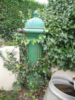 water pump1123 yd
Explorer Tom Water pump in Mullaghdoo Scotch dates from around 1890. Its cast-iron shaft and domed cap are fluted, with an acorn…
 Bonner's BarPub · 1191 yd
Explorer Tom Bonner's Bar is very colourful because Bonner probably painted it after drinking too much last Friday. The first…
 Holy well in Sliabh Mhullach DeargHoly well · 1482 yd
Explorer Tom At Sliabh Mhullach Dearg, the record describes a round hollow cut into rock as a holy well. Ó Muirgheasa wrote in 1936…
 The Banks, Naomh Muire GAA, Lower RossesGAA ground · 1.3 mi
 Sharkey’s BarPub · 1.3 mi
Explorer Tom Sharkey’s Bar in Annagary is a pub that sounds like it has a very opinionated owner named Sharkey. If he starts telling…
 Annagary HillMountain / peak · 1.7 mi
Explorer Tom Annagary Hill. A trigonometric point perched at just one hundred and six metres, looking down on its own little town…
 Mapped cemeteryCemetery · 2.0 mi
Explorer Tom “Mapped cemetery” in County Donegal has a secret talent for making the wind sound like it’s playing a very off-key…
 Inis FraoighIslet · 2.4 mi
Explorer Tom Inis Fraoigh means 'island of heather' and sits in a sheltered bay. I am curious if it is mostly just rock and salt air…

What do you know about this place?Tap to add a comment or ask a question