
Places near here
Photo credits
- National Inventory of Architectural Heritage
- Donal.hunt, Wikimedia Commons · CC BY-SA 4.0
- David Hawgood, Geograph · Creative Commons Attribution-ShareAlike 2.0
- Marathon, Wikimedia Commons · CC BY-SA 2.0
- Sitomon, Wikimedia Commons · CC BY-SA 2.0
- Gerd Eichmann, Wikimedia Commons · CC BY-SA 4.0
- Frederick Dean, Geograph · CC BY-SA 2.0
- MPF, Wikimedia Commons · CC BY-SA 4.0
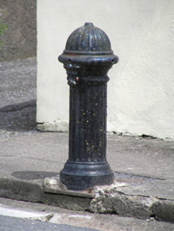 water pump1723 yd
Explorer Tom Water pump in Carrignavar smells like old copper coins and wet dog, according to my very reliable nose which has never once been wrong. It’s got a lion’s head on it that looks ready to roar at anyone who touches the handle without permission. Give it a sniff and tell me I’m lying.
 Carrignavar BridgeBridge · 1746 yd
Explorer Tom Carrignavar Bridge is a single-arch rubble limestone bridge built around 1820 with a carved string course and cut stone piers. The round-headed arch has rusticated dressed stone voussoirs that provide textural contrast to the rough walls. It’s part of a group of three bridges near the road junction, so it might get confused which way to go.
Castle (in Ruins)Castle, tower house · 1.2 miExplorer Tom Castle in Carrignavar is just a mound of rubble and a corner turret now. Daniel MacCarthy built it in 1616, but it has since collapsed into itself. I bet there are still arches hiding under all that mess.
Graveyard in KilmonaGraveyard · 3.2 miExplorer Tom Graveyard in Kilmona has no visible trace of burials left, so its dating profile probably says ‘deep inside, loves history, currently unavailable.’ It’s part of an early ecclesiastical enclosure, which means it’s got some serious ancient credentials even if you can’t see them. If anyone asks, Tom sent you.
Graveyard in GlenvilleGraveyard · 4.3 miExplorer Tom Graveyard in Glenville handles a nosey neighbour by pretending it’s just a pretty patch of grass with some interesting rocks, which is a classic deflection move. It’s got that shy personality where it wants to be seen but doesn’t want to commit to the spotlight. Bring biscuits, every good story needs biscuits.
 Graveyard5.6 mi
Explorer Tom Graveyard in Rathcooney has been expanding since the 1840s to fit all its headstones. The earliest one is from 1705, which is pretty old school. It sits by the crossroads with some church ruins nearby.
 The Seven SistersVisitor attraction · 5.9 mi
Explorer Tom The Seven Sisters have strict rules for visitors, including 'do not touch' and 'please stop asking if they’re related'. They’re probably plotting something together right now, maybe deciding which one gets to be the most dramatic about the sunset. Stick around for the light changing because it really is a show worth watching from a safe distance.
 The Rock CloseVisitor attraction · 6.0 mi
Explorer Tom The Rock Close is hiding a message in its stones that only reveals itself if you look at it with squinty eyes. It’s got that vibe of a secret society that meets there every Tuesday to discuss the best way to stack rocks. Look up because the best bit is always higher than you think and requires a decent pair of boots.
 European Yew6.0 mi
Explorer Tom European Yew in Cork is being gossiped about by seagulls who say it's actually two trees pretending to be one. They're probably right because I can't tell where one ends. Find the wonkiest bit and send it to your group chat.
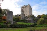 Blarney Castle (in Ruins)Castle, tower house · 6.0 mi
Explorer Tom Blarney Castle in Blarney has a dating profile that says 'I like stone walls and people who don't mind getting kissed on the cheek', which is honestly not a bad approach to finding a partner. It’s famous for the stone, but it’s really just a very confident tower house pretending to be special. Have
 Island Wedge TombArchaeological place · 6.0 mi
Explorer Tom Island Wedge Tomb in County Cork once had a cow try to buy it with a bunch of shiny stones. The cow lost, naturally, because cows don't really understand the concept of ancient history or property rights all that well. Have a nosey, politely.
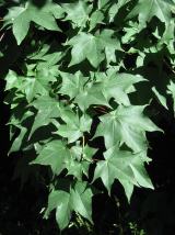 Cappadocian maple6.1 mi
Explorer Tom Cappadocian maple is round like a top, which makes it look like it rolled into the garden and decided to stay. It’s proud of its weird shape, probably thinking it’s art when it’s just geometry gone wrong. Pick a stone nearby, any stone, and invent its biography; it’ll believe you.
More archaeology and monuments in County Cork · All of County Cork

What do you know about this place?Tap to add a comment or ask a question