
What is recorded here
Places near here
Picture notes
- Computer-made picture. It does not show this monument.
- National Inventory of Architectural Heritage
- James Emmans, Geograph · CC BY-SA 2.0
- Computer-made picture. It does not show this mountain top.
- Picture: Go Visit Inishowen
- Computer-made picture. It does not show this playground.
- Kenneth Allen, Geograph · CC BY-SA 2.0
- Andreas F. Borchert, Wikimedia Commons · CC BY-SA 4.0
 Cross-inscribed pillar (present location) in Drumaville (tremone Ed)Cross-inscribed pillar (present location) · 165 ydComputer-made picture
Explorer Tom Cross-inscribed pillar in Drumaville is a bit of a shape-shifter. It’s now tucked inside a field wall, but it used to stand alone in Lacht Field with its own cairn. I find it charming that it got demoted from centre-stage to wall-support.
 Cross-inscribed pillar in Drumaville (tremone Ed)Cross-inscribed pillar · 191 ydComputer-made picture
Explorer Tom Cross-inscribed pillar in Drumaville has a T-bar terminal at the bottom, which looks like a little metal barbell. I bet it was originally a weight for a giant’s gym bag before someone decided to carve a circle into it.
 outbuilding199 yd
Explorer Tom Outbuilding in Drumaville, built c. 1800, wears a straw-thatched roof held down by netting and rope stays. Why did it need such fancy safety gear? Maybe it was afraid of the wind deciding to take its hat.
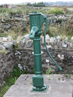 water pump935 yd
Explorer Tom Water pump in Carrowmenagh was erected around 1890 with a cow-tail handle and a fluted spout. The inventory remembers it as a village water source and gathering point. I got caught on the handle's funny name, then the ordinary work it did turned out to matter more.
 Tremone BayBeach / strand · 961 yd
Explorer Tom Tremone Bay has been keeping an icy secret in its rocks. Geological Survey Ireland records debris dropped by ancient ice in the bedrock at White Strand’s northwest end, roughly 590 to 570 million years old. I cannot blame the beach for looking smug; most places would brag about a history half that long.
 CrockduffMountain / peak · 2.1 miComputer-made picture
Explorer Tom Crockduff saw its most dramatic moment when a goat fell asleep on the summit and woke up as a legend. It has been napping ever since, claiming it is meditating for the good of all humanity. Pop by and tell it it's looking well.
 Bishop's HillMountain / peak · 2.5 miComputer-made picture
Explorer Tom Bishop's Hill is recorded as a mountain / peak in County Donegal. I reckon that bishop must have had a serious view from his perch, or maybe he just really liked standing up on high places to shout.
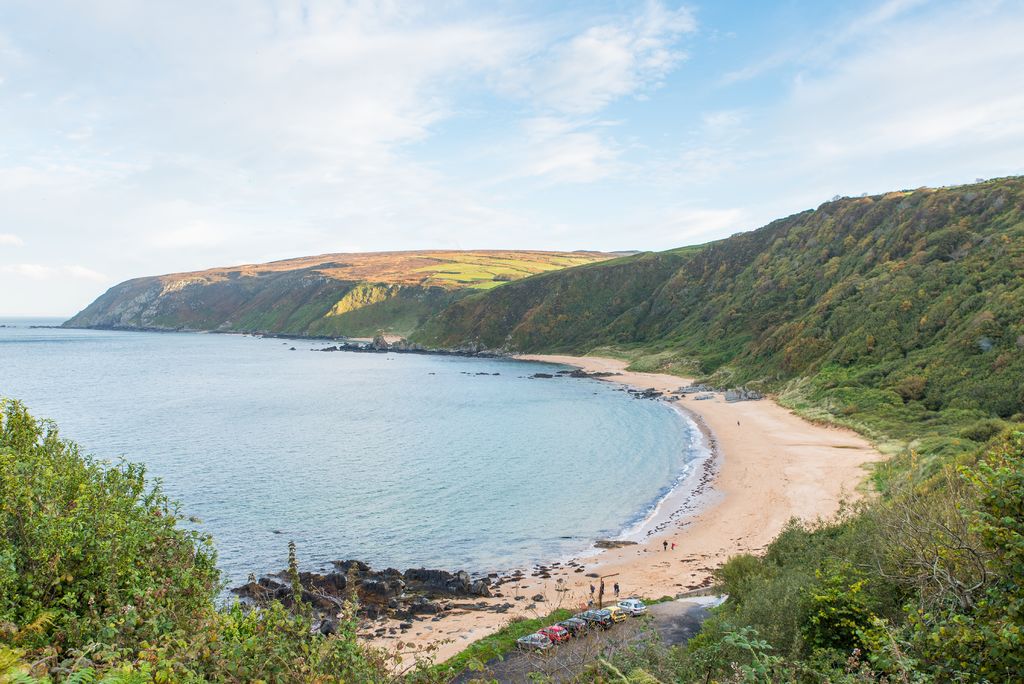 Kinnagoe BayBeach / strand · 2.8 mi
Explorer Tom Kinnagoe Bay has an impressive sense of timing. La Trinidad Valencera went down here in 1588, and the wreck waited until 1971 to be found. Nearly four centuries of suspense is rude, frankly. The cove sits below steep slopes, reached by a narrow road with a hairpin bend.
 Children's playground3.2 miComputer-made picture
Explorer Tom Children's playground in County Donegal has a reputation for being haunted by a very polite phantom. Spook the next person you meet with this info, they’ll appreciate the mystery. Tell the next person you meet it's haunted. It might be.
 Orchard BarPub · 3.3 mi
Explorer Tom Orchard Bar in County Donegal has an unlikely celebrity friend who only visits when the cider is fresh. I’d bet they keep a secret orchard just for their own private boozy harvest. Wave at the cows, they're the real locals.
 McGrory'sHotel · 3.7 mi
Explorer Tom McGrory’s in Culdaff looks like it’s been standing there since the last glacial period on Malin Road. Check if the heating works before you commit to staying the night, trust me on this one. Give it a pat on the way past, it's had a long life.
 CastleCastle, unclassified · 4.0 mi
Explorer Tom Castle in Carthage may survive only as shapeless stone mounds on a promontory. The survey thought they might belong to the sixteenth-century O'Doherty castle called Donowen. A wall closed the landward side, while another guarded a sea approach. Those defences are recorded; the exact shape of the lost castle is not.
More walking routes in County Donegal · All of County Donegal

What do you know about this place?Tap to add a comment or ask a question