
Places near here
Photo credits
- National Inventory of Architectural Heritage
- Keith Salvesen, Wikimedia Commons · CC BY-SA 2.0
- Muimhneach, Wikimedia Commons · CC BY-SA 4.0
- Andreas F. Borchert, Wikimedia Commons · CC BY-SA 4.0
- P L Chadwick, Wikimedia Commons · CC BY-SA 2.0
- Bob Jones, Geograph · CC BY-SA 2.0
- Night of the Big Wind, Wikimedia Commons · CC BY-SA 3.0 nl
- Adrian King, Geograph · CC BY-SA 2.0
- Willow, Wikimedia Commons · CC BY 2.5
- Colin Park, Geograph · CC BY-SA 2.0
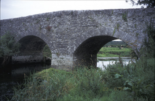 Poplar BridgeBridge · 1243 yd
Explorer Tom Poplar Bridge is a hump-back charmer from 1810 that looks like it's trying to hide a secret in its arches. I bet it was built to impress some very serious horse. Take a mate and argue about whether it was for horses or ghosts; neither will admit defeat.
 Sheela na GigPublic artwork · 1311 yd
Explorer Tom Sheela na Gig in County Clare is a mysterious relic, where art and history meet in a timeless dance
 Sheela-na-gig in KillinaboySheela-na-gig · 1313 yd
Explorer Tom Sheela-na-gig in Killinaboy is built into the church wall, looking like a grim, ribbed statue pouring something out with zero shame. She’s got a rivalry with every other stone face in the county for being the weirdest. Go back in winter, it's a different animal.
 Kilinaboy Church (in ruins)Church · 1317 yd
Explorer Tom Kilinaboy Church holds a fake world record for being the most photogenic ruin in County Clare, according to its own PR team. It was founded by Iníon Baoith, so it's got serious saint-cred going on. Great spot to propose. Or at least to propose lunch before you do.
 Killinaboy Round TowerVisitor attraction · 1322 yd
Explorer Tom Killinaboy Round Tower has me thinking it’s a tower that’s as old as the name suggests, but I’m still in doubt.
 Inchiquin Castle (in ruins)Castle, tower house · 1617 yd
Explorer Tom Inchiquin Castle is perched on a rocky bluff, looking down its nose at the lough below. Built by a king, ruined by time, and still acting like it's the center of the universe. Wave at the cows, they're the real locals.
Inchiquin CastleRuins · 1620 ydExplorer Tom Inchiquin Castle is recorded as ruins in County Clare, its open map record supplying location and linked names or public references.
 Cross in RoughanCross · 1662 yd
Explorer Tom Cross in Roughan is a fragment that got kicked out of the club. It’s now living its best life in a depot. Go back in winter, it's a different animal.
 Inchiquin IslandIslet · 1.2 mi
Explorer Tom Inchiquin Island! A small islet with a name that sounds like it could be part of a royal lineage, what secrets does it keep in County Clare?
 Rock IslandIsland · 1.3 mi
Explorer Tom Rock Island, with its rugged silhouette, stands proudly near Lough Inchiquin’s southern shore.
 European ash4.7 mi
Explorer Tom European ash that probably thinks it's a fancy French willow but with better posture. Bring your worst joke, the place has heard worse from my mates.
 Burren Centre KilfenoraVisitor information · 5.0 mi
Explorer Tom Burren Centre Kilfenora is a haven for those seeking the beauty of the Burren in County Clare
More archaeology and monuments in County Clare · All of County Clare

What do you know about this place?Tap to add a comment or ask a question