
What is recorded here
Imagine Cromwell's Castle in Esker (Longford BY) guarding the crossing at Banagher while a traveller argues that their load will fit through just fine. The person in charge would ask for one careful attempt, then watch the traveller reconsider the meaning of fine.
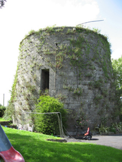
Detached rectangular-plan two-storey rubble limestone fortification, built c.1650, converted c.1805 for use as battery, having round turrets to south-west and south-east corners and curved corners at north-west and north-east. Now disused. Battered base to south-east corner tower. Surrounded to east, south and west by stone-lined moat. Dressed limestone parapet and coping. Camber-arch door opening to south elevation with yellow brick voussoirs and reveals, and having timber fittings. Square-headed window openings to east elevation, with yellow brick jambs and limestone sills. Narrower windows elsehwere with bars.
The fortification known as Cromwell’s Castle was strategically sited to protect the river crossing at Banagher. Built in the mid-seventeenth century, it was later converted for use as a battery and thus formed part of an important group of late eighteenth and early nineteenth-century defences constructed to guard against the threat of a Napoleonic invasion. The defences along the River Shannon are of particular importance due to their inland location. The unusual and distinctive form of the building is a notable landscape feature today.
From the Buildings of Ireland (National Inventory of Architectural Heritage) record 30410908
This does not grant access. Most recorded buildings are privately owned; view them only from public ground unless the owner allows entry.
Places near here
 Canal HouseLock keeper's house · 47 yd
 Banagher TowerMartello tower · 90 yd
 Banagher Martello TowerMartello tower · 95 ydBanagher MarinaHeritage attraction · 330 ydCorrigans CornerMemorial · 742 yd
 CrossCross, High cross · 799 yd
 Garry Castle in ruinsCastle, tower house · 1.7 mi
 Cloghan CastleCastle · 3.2 mi
 MeelickVisitor information · 3.5 mi
 Horse-chestnut4.2 mi
 Clonfert CathedralHeritage attraction · 4.2 mi
 European Yew4.2 mi
Pictures: National Inventory of Architectural Heritage; Brian Shaw, Wikimedia Commons · CC BY-SA 2.0; A.-K. D., Wikimedia Commons · CC BY-SA 4.0; Mike Searle, Geograph · CC BY-SA 2.0; Corcs999, Wikimedia Commons · CC BY-SA 3.0; Kieran Campbell, Geograph · CC BY-SA 2.0; Stephan van Helden, Wikimedia Commons · CC BY-SA 4.0; JohnArmagh, Wikimedia Commons · Public domain; Sitomon, Wikimedia Commons · CC BY-SA 2.0
More historic places in County Galway · All of County Galway
What do you know about this place?