Places near here
Photo credits
- GordonPin, Wikimedia Commons · CC BY-SA 4.0
- National Inventory of Architectural Heritage
- Nigel Cox, Wikimedia Commons · CC BY-SA 2.0
- Golfing in Ireland; photographer not stated, Source publisher
- Matthew Hatton, Geograph · CC BY-SA 2.0
- Colin Park, Geograph · CC BY-SA 2.0
- Den Donovan from London, Wikimedia Commons
- Terryballard, Wikimedia Commons · CC BY-SA 3.0
- Wikimedia Commons contributor · Public domain
- Irina Guerin, Wikimedia Commons · CC BY-SA 4.0
 Church in Glebe (trughanacmy By., Ballynahaglish Ed)Church · 735 yd
Explorer Tom Church in Glebe smells like wet sheep and regret, which is very authentic for Kerry. It was once called Scothfig, a…
Ballynahaglish ChurchChurch/chapel · 735 ydExplorer Tom Ballynahaglish Church is a ruin now, with ivy covering its limestone walls like a green blanket. It claims there’s a…
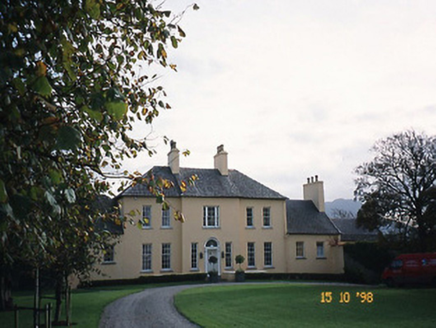 Churchill HouseRectory/glebe/vicarage/curate's house · 786 yd
Explorer Tom Churchill House in Glebe Ballynahaglish has strong opinions about the road leading to it, mostly that it’s too bumpy.…
 Barrow HouseHouse · 1643 yd
Explorer Tom Barrow House hosted a dance that went so far they had to add a dormer attic to hide. The roughcast rendered walls have…
 Tralee Golf ClubGolf course · 1.2 mi
 Barrow Round Castle (in ruins)Castle, tower house · 1.7 mi
Explorer Tom Barrow Round Castle sits inside an old fort that was reused as a bawn, creating a kind of historical sandwich that no…
 Fenit Castle (in ruins)Castle, tower house · 1.8 mi
Explorer Tom Fenit Castle in Fenit Within is officially no longer visible or destroyed, which is a bit rude for a record. It used to…
 Fenit BeachBeach / strand · 1.8 mi
Explorer Tom Fenit Beach has mastered the useful trick of feeling like a seaside escape while keeping Tralee within reach. Its…
 Rathoneen Castle (remains of)Castle · 2.0 mi
Explorer Tom Rathoneen Castle is basically a pile of rocks that thinks it’s a fortress, and honestly, I’m not arguing with that. The…
 Tralee BayBay · 2.5 mi
Explorer Tom Tralee Bay is so broad I would need a second lunch just to argue about where its edges are. Kerry Head closes the…
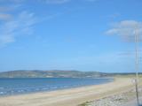 Banna StrandBeach / strand · 2.9 mi
Explorer Tom Banna Strand has enough sand for my footprints to disappear before I can boast about the distance walked. The beach…
 Raheenyhooig Grave Yard, dotted outlineBurial ground · 23 mi
Explorer Tom Raheenyhooig graveyard is sick of being asked if it’s a rath, because it clearly isn’t, so stop guessing and start…
More waterfalls, wells and springs in County Kerry · All of County Kerry

What do you know about this place?Tap to add a comment or ask a question