
What is recorded here
From OpenStreetMap (© OpenStreetMap contributors) n3745513327
Places near here
Picture notes
- Computer-made picture. It does not show this monument.
- Computer-made picture. It does not show this playground.
- Richard Webb, Wikimedia Commons · CC BY-SA 2.0
- National Inventory of Architectural Heritage
- Computer-made picture. It does not show this walking route.
- David Dixon, Geograph · CC BY-SA 2.0
- Computer-made picture. It does not show this mountain top.
- Kenneth Allen, Geograph · CC BY-SA 2.0
- Andreas F. Borchert, Wikimedia Commons · CC BY-SA 4.0
 CairnCairn, unclassified · 283 ydComputer-made picture
Explorer Tom Cairn in Ballynakeeloge sits proudly on the summit of Crocknamaddy, showing off its eight-point-four-metre diameter to anyone who climbs high enough. I imagine those large random stones are having a very loud argument about who is actually in charge of this rough mountain patch.
 Enclosure in FoffanaghEnclosure · 1484 ydComputer-made picture
Explorer Tom Enclosure in Foffanagh sits on a rocky slope with sweeping views of Lough Swilly. It’s just a pile of stones and a single lintel, so I guess we’re not sure if it was a hut or a grave. Either way, the view from this low rise is absolutely stunning.
 Children's playground1.3 miComputer-made picture
Explorer Tom Children's playground in County Donegal is where kids go to invent new games that involve imaginary dragons and real mud. The sandcastle builder over there is probably the king of this little kingdom right now. Go now, before it gets famous and they put up fences.
 Slieve MainMountain / peak · 1.3 mi
Explorer Tom Slieve Main is recorded as a mountain / peak in County Donegal, and it looks like a solid, reliable sort of hill. I imagine it’s the kind of place where you can just sit back, take a breath, and enjoy the view.
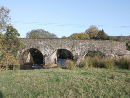 Druminderry BridgeBridge · 1.5 mi
Explorer Tom Druminderry Bridge is a c. 1800 work of stone that has spanned the Crana River for two hundred years without complaining. Those elegant elliptical arches prove you don’t need modern tech to build something that lasts forever.
 Glashagh BridgeBridge · 1.5 mi
Explorer Tom Glashagh Bridge is a humpback beauty from c. 1860 that refuses to look tired. The elliptical arches and squared voussoirs show off some serious masonry chops, proving it’s not just a random pile of rocks. It’s a proper picturesque landmark.
 Old Carn Road Drovers TrailOfficial walking route · 1.9 miComputer-made picture
Explorer Tom Old Carn Road Drovers Trail is where history walks with you, assuming it hasn't been replaced by a very slow jogger. Five point six kilometers of moderate effort awaits. Look up, the best bit is always higher than you think.
 Slí Croí Inis EoghainOfficial walking route · 1.9 miComputer-made picture
Explorer Tom Slí Croí Inis Eoghain is a heart-shaped loop, or at least it feels like one after seven point six kilometers of moderate hiking. It's a nice size for a day out. Tell your mates you found it first.
 The North PolePub · 2.0 mi
Explorer Tom The North Pole in Donegal? That’s geographically chaotic, but I love it. I bet they serve ice cream that melts instantly because of the humidity. Enjoy the slush!
 DamphMountain / peak · 2.0 miComputer-made picture
Explorer Tom Damph sits in County Donegal, a peak with no recorded access details. The name sounds like it is trying to explain itself with a flat stone, but the map just offers you a polite shrug.
 Tullyarvan Mill HostelHostel · 3.6 mi
Explorer Tom Tullyarvan Mill Hostel smells like damp socks and ancient secrets. The millstone might still be grinding something up in there. Check if the floorboards creak when you stomp around.
 O'Doherty's KeepCastle · 4.1 mi
Explorer Tom O'Doherty's Keep is recorded as a castle in County Donegal, and its history with the Ó Dochartaigh clan makes it a significant part of Inishowen’s past. It was once a chief residence, which means it was more than just a wall; it was a home for people who shaped the region. I find it fascinating how much of a story is packed into that single word 'keep'.
More mountains and hills in County Donegal · All of County Donegal

What do you know about this place?Tap to add a comment or ask a question