
What is recorded here
From OpenStreetMap (© OpenStreetMap contributors) n3761403467
Places near here
Picture notes
- Computer-made picture. It does not show this monument.
- National Inventory of Architectural Heritage
- Computer-made picture. It does not show this mountain top.
- Kenneth Allen, Geograph · CC BY-SA 2.0
- Computer-made picture. It does not show this playground.
- Rossographer, Geograph · CC BY-SA 2.0
- Vadim Manuylov, Wikimedia Commons · CC BY-SA 3.0
- Ronnie Nijboer, Wikimedia Commons · CC0
 Fairy fort / ringfort in An Bhealtaine UachtarachFairy fort / ringfort · 1.0 miComputer-made picture
Explorer Tom Fairy fort / ringfort in An Bhealtaine Uachtarach is officially 'Ardbane', but the map just shows a small natural rock platform on a slope. It’s a bit of a letdown, really; you’re basically squinting at a boulder and hoping it hides a secret.
 Cashelnagor Fairy Fort SiteFairy fort / stone ringfort · 1.3 miComputer-made picture
Explorer Tom Cashelnagor Fairy Fort Site is a local legend, but honestly? It’s just a rock platform wrapped in a modern stone wall. The maps are empty, so it’s your word against theirs, go stand on that rocky edge and wonder if the 'fort' was ever more than a fancy hill.
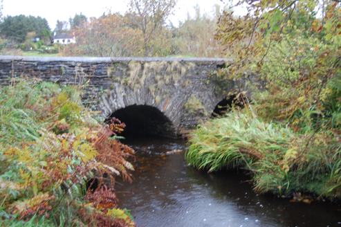 Fawnaboy BridgeBridge · 1.3 mi
Explorer Tom Fawnaboy Bridge crosses the Glenna River on two arches, built around 1810. Triangular cut-waters stand between the spans, while field-stone blocks form the curves. Two rounded arches and sharp points: the stonework changes its geometry halfway across the river.
 Carn TraonachMountain / peak · 1.5 miComputer-made picture
Explorer Tom Carn Traonach may mean 'cairn of corncrakes'. I would love to hear those birds arguing over whose hill it is. A name guide also records an old festive assembly here, giving the peak a story without turning it into a festival you can book.
 Taobh an LeithidMountain / peak · 1.7 miComputer-made picture
Explorer Tom Taobh an Leithid sounds like a Gaelic phrase for 'I left my keys at home.' It’s definitely got some character hidden under that name. Stick around for the light changing, it's a show you don't want to miss.
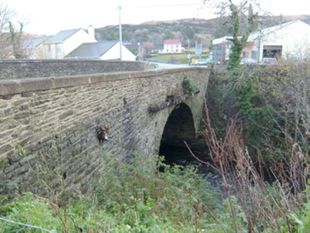 Droicheadh Bhedlam [Bedlam Bridge]Bridge · 1.8 mi
Explorer Tom Droicheadh Bhedlam [Bedlam Bridge] crosses the Glenna River on a single stone arch. The river sounds as though it is shouting at the bridge to calm down. What a name for such a polite arch!
 Maggie Dan'sRestaurant · 2.2 mi
Explorer Tom Maggie Dan’s serves pizza, which is basically bread and cheese pretending to be Italian, and I bet the bargain that built it was a slice of regret. If it tastes like disappointment, grab a slice for me anyway because I’m too polite to complain in public. Bring a flask of something warm and a story to swap.
 Ostan Loch AltanHotel · 2.2 mi
Explorer Tom Ostan Loch Altan along the N56 pretends to be grand but looks like a haunted shed with delusions of grandeur. Grab me a warm drink before the ghosts start billing us for our stay there. Bring a map, get lost anyway, that's the fun.
 Children's playground3.5 miComputer-made picture
Explorer Tom Private access means the owners are keeping their secrets close, probably for good reason. I bet the swings only move on full moons. A proper spot for a flask of tea and a big think.
 MagheraroartyOfficial bathing water · 3.6 mi
Explorer Tom Magheraroarty has pulled a fine trick on the map: Atlantic on one side of a sandy spit, Ballyness Bay on the other, Inishbofin up north. That is enough directions for one beach to manage. The western shore takes a strong Atlantic wash, so I would keep my admiration on dry sand.
 Monterey Cypress4.4 mi
Explorer Tom Monterey Cypress in County Donegal is pretending to be from California. It's a bit out of place, like a surfboard in a bog. It wants permission for everything. Tell it to relax and let the wind do its hair.
 Wych Elm4.4 mi
Explorer Tom Wych Elm in County Donegal is getting a bit ratty, as they do, and it's very particular about who can touch it. It might need permission to just be a tree. Tell it to stop shedding so much everywhere, mate.
More mountains and hills in County Donegal · All of County Donegal

What do you know about this place?Tap to add a comment or ask a question