
Places near here
Photo credits
- Colin Park, Geograph · CC BY-SA 2.0
- National Inventory of Architectural Heritage
- Kenneth Allen, Wikimedia Commons · CC BY-SA 2.0
- John Martin, Geograph · CC BY-SA 2.0
- Kenneth Allen, Geograph · CC BY-SA 2.0
- Patrice78500, Wikimedia Commons · Public domain
- Kieran Evans, Geograph · CC BY-SA 2.0
- N Chadwick, Geograph · CC BY-SA 2.0
- Rod Grealish, Geograph · CC BY-SA 2.0
 CrockfaddaMountain / peak · 2.2 mi
Explorer Tom Crockfadda has an undefined summit. I love that the highest point on the mountain doesn't actually exist, so you can never technically reach the top. It’s the ultimate cheat for anyone trying to prove they made it.
 Crockfadda North-East TopMountain / peak · 2.7 mi
Explorer Tom Crockfadda North-East Top is getting picked on by the wind because it insists on wearing a tiny stone cairn like a hat. The breeze keeps trying to blow it off, but the peak holds on tight with sheer determination and a bit of stubbornness. It’s basically a giant game of keep-away. Perfect detour when the satnav has a meltdown.
 icehouse4.1 mi
Explorer Tom Icehouse in Derrynacarrow is a round stone building set into a hillside, built around 1860. The survey says it was apparently made to store ice for a salmon fishery on the Gweebarra River. Before an electric fridge, this two-cell building had the cold-storage job.
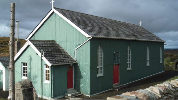 Teach Pobail Phádraig Naofa [Saint Patrick's Catholic Church]Church/chapel · 4.1 mi
Explorer Tom Teach Pobail Phádraig Naofa [Saint Patrick's Catholic Church] was built around 1935 with green-painted corrugated-iron walls. Its pointed windows and cross finials still say church, even though the wall material looks more like a farm shed. I did not expect that pairing.
 Cairn, Coolvoy, DoocharyPublicly named cairn · 4.2 mi
Explorer Tom Cairn, Coolvoy, Doochary is a name that sounds like it belongs to a place with a lot of local history and stories. I imagine it’s one of those spots where the ground has been used by people for a very long time, maybe for marking boundaries or gathering. It’s a name that makes you curious about what went on there.
 Cairn, LoughanurePublicly named cairn · 4.3 mi
Explorer Tom Cairn, Loughanure is a place where the name suggests a connection to water and perhaps a specific local story. I imagine it’s one of those spots that has been part of the landscape for a long time, maybe used by people who lived nearby. It’s a name that makes you think about how places get their names.
 Errigal Youth HostelHostel · 5.0 mi
Explorer Tom Errigal Youth Hostel in County Donegal is where dreams go to get squished under mattresses. It's cozy if you define cozy as 'crowded' and 'slightly damp'. Bring a notebook and write the bit I made up for your diary.
 McGeady's BarPub · 5.1 mi
Explorer Tom McGeady’s Bar is sitting there looking suspiciously quiet in County Donegal, waiting for someone to ask if they’ve had any ghosts. Order something strong and blame all the damp on them instead, because that’s just how it works sometimes. Go in good boots and better humour.
 Páirc Naisiúnta Ghleann Bheatha - Glenveagh National ParkNature reserve · 5.4 mi
Explorer Tom I spotted a golden eagle and immediately pretended it had come to inspect me. Glenveagh National Park spreads across roughly 170 square kilometres of Donegal, which makes any plan to see it all before lunch a fine piece of nonsense. Lough Veagh runs through the glen, mountains rise around it, and red deer move through the wider country. Golden eagles were reintroduced here in 2000, a bold return for a bird once lost from the region. This landscape also carries the history of the Derryveagh Evictions, when 224 people were driven from the estate in 1861; the views cannot be separated from that record. The deer have better routes through this country than any shortcut I could invent. Later owner Henry McIlhenny gave the estate to the Irish state in the 1970s. Public park paths offer different lengths of walk, while castle tours have separate arrangements, so check routes and weather before setting off. Choose one stretch of glen and let it be enough; the mountain will still be here for the next visit.
 Braade StrandBeach / strand · 7.5 mi
Explorer Tom “Braade Strand” in County Donegal would bring a massive bucket of sand and a grumpy crab to any party, which honestly sounds like a perfect combo for most gatherings. It’s a stretch of shore where the wind is loud enough to drown out your inner critic and make you feel small and free. Practise your Irish on it, it won't correct you.
 CarrickfinnOfficial bathing water · 8.0 mi
Explorer Tom Carrickfinn brought a beach and then sneaked a meadow in behind it. Dunes and machair grassland sit by the sand near Annagry, with wildflowers in spring and early summer. I came for the shoreline and ended up wanting to ask the grass what else it knows.
 Astelleen Burn WaterfallWaterfall · 8.2 mi
Explorer Tom Astelleen Burn Waterfall is three kilometres from Glenveagh and seems to be guarded by a ghost who is far too lazy to actually haunt anyone properly. The Irish name translates to 'waterfall of the flood,' which is dramatic for something that mostly just slops along quietly. Go now, before it gets famous.
More mountains and hills in County Donegal · All of County Donegal

What do you know about this place?Tap to add a comment or ask a question