
Places near here
Photo credits
- National Inventory of Architectural Heritage
- David Dixon, Geograph · CC BY-SA 2.0
- Kenneth Allen, Geograph · CC BY-SA 2.0
- C.B.Doak (user Zorba the Geek ), Wikimedia Commons · Public domain
- Maker named on the Wikimedia Commons picture page · CC BY-SA 2.5
- Rossographer, Wikimedia Commons · CC BY-SA 2.0
- Joseph Mischyshyn, Geograph · CC BY-SA 2.0
- Akira7ink, Wikimedia Commons · CC BY-SA 4.0
- Maker named on the Wikimedia Commons picture page · Public domain
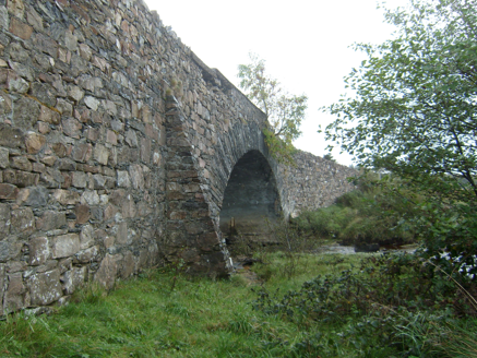 Owencarrow BridgeBridge · 1.3 mi
Explorer Tom Owencarrow Bridge crosses the Owencarrow River in one stone arch, built around 1860 and possibly incorporating older…
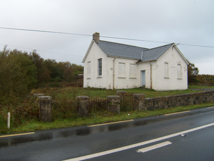 Scoil Náisiúnta Dhruim na Ráth [Drumnaraw National School]School · 1.3 mi
Explorer Tom Drumnaraw National School would use its lotto win to build a second entrance so the boys and girls could stop glaring…
 Glenveagh National Park Visitor CentreVisitor information · 2.2 mi
Explorer Tom Glenveagh National Park Visitor Centre is where they hand you the keys to the kingdom of birches. It’s the second…
 Mcnulty's BarPub · 2.5 mi
Explorer Tom McNulty’s Bar is likely full of people who think they’re great at darts but actually miss everything. Watch them fail…
 Rose's BarPub · 2.6 mi
Explorer Tom Rose's Bar in County Donegal is blooming with potential, or at least it smells like rose water and old beer. Go there…
 MuckishMountain / peak · 2.7 mi
Explorer Tom Muckish looks as though a giant pig lay down across north Donegal and refused to move. The Irish name, An Mhucais…
 Sessile Oak2.7 mi
Explorer Tom Sessile Oak is hosting a ghost who is far too lazy to actually haunt anyone, preferring to nap in the hollows instead.…
 CairnCairn, unclassified · 2.8 mi
Explorer Tom The cairn on top of Muckish Mountain was recorded as a flat-topped pile about eight metres across and 1.5 metres high.…
 Muckish Mountain CairnCairn, unclassified · 2.8 mi
Explorer Tom Muckish Mountain Cairn is a 22-metre stone pile that practically shouts for attention from the mountain's lower edge.…
 The Bridge of TearsMemorial · 3.1 mi
Explorer Tom The Bridge of Tears carried more than traffic through Muckish Gap. Families once came this far with people leaving for…
 Master Sword in StoneHeritage attraction · 3.5 mi
Explorer Tom The Master Sword in Stone here is basically a giant Lego piece that someone left behind after getting bored of the…
 English holly3.7 mi
Explorer Tom English holly in County Donegal had an escape plan involving its berries and a very determined squirrel who never quite…
More mountains and hills in County Donegal · All of County Donegal

What do you know about this place?Tap to add a comment or ask a question