What is recorded here
From OpenStreetMap (© OpenStreetMap contributors) n332373248
Places near here
Photo credits
- Albert Bridge, Wikimedia Commons · CC BY-SA 2.0
- Dave Napier, Wikimedia Commons · CC BY-SA 2.0
- Kenneth Allen, Geograph · CC BY-SA 2.0
- Rossographer, Wikimedia Commons · CC BY-SA 2.0
- DColt ( talk ), Wikimedia Commons · Public domain
- Cormac Duffin, Geograph · CC BY-SA 2.0
- Anne Burgess, Wikimedia Commons · CC BY-SA 2.0
- Rossographer, Geograph · CC BY-SA 2.0
- N Chadwick, Wikimedia Commons · CC BY-SA 2.0
- Kenneth Allen, Wikimedia Commons · CC BY-SA 2.0
- JohnArmagh, Wikimedia Commons · CC BY-SA 3.0
_-_geograph.org.uk_-_796085.jpg/250px-Breen_forest_near_Ballycastle_(1)_-_geograph.org.uk_-_796085.jpg "Photo: Albert Bridge, Wikimedia Commons · CC BY-SA 2.0") Breen ForestForest · 1.6 mi
Breen ForestForest · 1.6 miExplorer Tom Breen Forest in County Antrim is a whole view of greenery, selected after careful review of its exact name.
 Pre-norman Church & Round Tower; Medieval Parish Church; Post-medieval Church & Graveyard: Armoy Church & Round Tower in GlebePre-norman Church & Round Tower · 2.9 mi
Explorer Tom Armoy Church and its Round Tower are state-care scheduled monuments, resembling a Presbyterian church in appearance; it’s a striking pre-Norman relic to admire.
 Causeway Coast and Glens Heritage TrustVisitor information · 3.4 mi
Explorer Tom The Causeway Coast and Glens Heritage Trust on Main Street is packed with stories about this rugged and beautiful part of County Antrim.
 KnocklaydMountain / peak · 3.5 mi
Explorer Tom There’s a fence on Knocklayd, guarding its secrets in County Antrim while we wonder what lies beyond it.
 Slieveanorra ForestForest · 4.1 mi
Explorer Tom Slieveanorra Forest looks moody on wet foggy days, which is exactly the kind of atmosphere I like when exploring woods in County Antrim.
 Ballypatrick Forest Trails - 1 Cairn TrailWalking route · 4.8 mi
Explorer Tom Step onto the Cairn Trail and ponder ancient double-horned burial sites. History is literally under your feet here!
May2007.jpg/250px-Tievebulliagh(AnneBurgess)May2007.jpg "Photo: Anne Burgess, Wikimedia Commons · CC BY-SA 2.0") TievebulliaghMountain / peak · 5.3 mi
TievebulliaghMountain / peak · 5.3 miExplorer Tom Tievebulliagh near Tully features porcellanite outcrops on its slopes, once used to craft ancient stone axes.
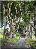 The Dark HedgesViewpoint · 5.5 mi
Explorer Tom Stand at The Dark Hedges on the Bregagh Road and marvel at the sheer number of daily tourists.
 Ramoan Presbyterian ChurchChurch · 5.6 mi
Explorer Tom The Ramoan Presbyterian Church is a Grade B listed building that I suspect has hosted many solemn and stirring sermons over the years.
 Gracehill HouseHouse · 5.7 mi
Explorer Tom Gracehill House is a charming Grade B1 listed house in County Antrim, waiting for you to admire its historic presence from the street.
 Ballycastle MuseumMuseum · 6.1 mi
Explorer Tom Visit Ballycastle Museum, where admission is free! It’s a museum in County Antrim packed with local tales and friendly faces waiting to greet you.
 Bonamargy FriaryArchaeological place · 6.3 mi
Explorer Tom Bonamargy Friary offers a glimpse into monastic life with its remaining structures, a peaceful spot for imagining old prayers and quiet times.
More mountains and hills in County Antrim · All of County Antrim

What do you know about this place?Tap to add a comment or ask a question