
What is recorded here
From OpenStreetMap (© OpenStreetMap contributors) n3807112302
Places near here
Picture notes
- Computer-made picture. It does not show this mountain top.
- Computer-made picture. It does not show this monument.
- William Frederick Wakeman (1822-1900), Wikimedia Commons · Public domain
- Andreas F. Borchert, Wikimedia Commons · CC BY-SA 4.0
- Computer-made picture. It does not show this garden.
- Andreas F. Borchert, Wikimedia Commons · CC BY-SA 3.0 de
- National Inventory of Architectural Heritage
- Kenneth Allen, Geograph · CC BY-SA 2.0
- Computer-made picture. It does not show this walking route.
 OughtadreenMountain / peak · 1.6 miComputer-made picture
Explorer Tom Oughtadreen in County Donegal is waiting for you to perform your best dramatic tour-guide voice, complete with hand gestures. Perfect spot to practise your best tour-guide voice, even if there’s no audience present at all.
 Loughfad HillMountain / peak · 1.9 miComputer-made picture
Explorer Tom Loughfad Hill makes a moaning sound at night that sounds suspiciously like a disappointed uncle. It’s probably just the wind being dramatic about something. Bring a friend who talks too much and let the place shut them up for good.
 Enclosure in Saints IslandEnclosure · 2.2 miComputer-made picture
Explorer Tom Enclosure in Saints Island was St. Patrick's monastic base, founded back in the fifth century. The east half is basically a graveyard now, so don't get too cosy with the stones. It’s a weird little patch on Lough Derg, and I imagine pilgrims once arriving here to check their souls.
 Saints IslandIsland · 2.2 mi
Explorer Tom Saints Island sounds like the place to land for the Lough Derg pilgrimage, but that is Station Island next door. This island held the early monastery; Lough Derg calls it overgrown and inaccessible. Even my map needs the two islands kept straight.
 Grave YardGraveyard · 2.2 miComputer-made picture
Explorer Tom Saints Island's graveyard belongs to a much older Lough Derg story. The account says pilgrims once used a road and a wooden bridge to reach the island; the survey wondered whether boulders in the lake were bridge supports. Tom would like to know who first drew that route.
 St. Parick's Catholic BasilicaChurch/chapel · 2.7 mi
Explorer Tom St. Parick's Catholic Basilica is an octagonal masterpiece on Station Island, designed by William Scott who based the plan on San Vitale in Ravenna. It cost over £80,000 to build and features stained glass by Harry Clarke, making it a stunning pilgrimage site.
 The CloisterGarden · 2.7 miComputer-made picture
Explorer Tom The Cloister in County Donegal is probably where monks went to complain about the canteen food. I bet they hid extra biscuits under the floorboards just to be spiteful. Count the crows, then count again and panic slightly.
 Station IslandIsland · 2.8 mi
Explorer Tom Station Island is the Lough Derg pilgrimage island; the older monastery island is its neighbour, Saints Island. The traditional pilgrimage lasts three days. I would want the current dates and a proper booking sorted before I packed, because a lake crossing deserves more planning than my usual wandering.
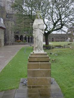 monument2.8 mi
Explorer Tom Monument in Station Island has three marble saints standing on sandstone blocks, but only one was made locally. I picture St. Joseph arriving from Italy via a very slow boat in 1891 while Patrick O’Neill’s Virgin Mary just stands there waiting for the unpacking to finish.
 Patrick the PilgrimMemorial · 3.2 mi
Explorer Tom Patrick the Pilgrim is a memorial that’s clearly been on a long journey to get here. St. Patrick’s Purgatory is in the background, which suggests this guy had some serious spiritual homework to do. Stand where the owner stood and practise looking smug.
 Lough Derg Pilgrim PathOfficial walking route · 3.3 miComputer-made picture
Explorer Tom Lough Derg Pilgrim Path is nine kilometres of easy walking where people go to find peace and get blisters instead. It’s a loop, so the suffering comes back around to you. Get there early and have it all to yourself, unless they’re meditating nearby.
 Leghowney Loop WalkOfficial walking route · 4.6 miComputer-made picture
Explorer Tom Leghowney Loop Walk is six point nine kilometres of moderate effort where you’ll pretend to enjoy the silence. It’s a loop, so you end up where you started, just slower. Look up, the best bit is always higher than you think, probably.
More mountains and hills in County Donegal · All of County Donegal

What do you know about this place?Tap to add a comment or ask a question