What is recorded here
From OpenStreetMap (© OpenStreetMap contributors) n3812498837
Places near here
Photo credits
- National Inventory of Architectural Heritage
- louise price, Geograph · CC BY-SA 2.0
- louise price, Wikimedia Commons · CC BY-SA 2.0
- C Michael Hogan, Wikimedia Commons · CC BY-SA 2.0
- Ronnie Nijboer, Wikimedia Commons · CC0
- EecherplazGinkgo06.jpg : Cayambe derivative work: Ginkgotree ( talk ), Wikimedia Commons · CC BY-SA 3.0
- Kenneth Allen, Wikimedia Commons · CC BY-SA 2.0
- Kenneth Allen, Geograph · CC BY-SA 2.0
- P L Chadwick, Geograph · CC BY-SA 2.0
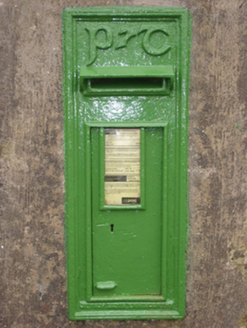 post box1547 yd
Explorer Tom Post box in Croagh sports raised P&T monogram in Gaelic script. I picture those fancy letters wiggling around, trying to hide a secret message from the mail carrier who never checks under them.
 Killin HillMountain / peak · 2.0 mi
Explorer Tom Killin Hill sits in County Donegal, recorded as a peak with access details that remain completely unknown. The caption mentions it is three kilometres from Frosses, which makes me wonder if the hill is just hiding behind its neighbour to avoid being found.
 Drumlaghtafin HillMountain / peak · 2.2 mi
Explorer Tom Drumlaghtafin Hill sits quietly between Leagans Hill and the Gortnalagan townland, keeping its access details firmly under wraps. The name is such a mouthful that I suspect it’s just trying to trip up anyone brave enough to attempt a pronunciation challenge without a map.
 Carraduffy / Killin Court TombCourt tomb · 2.4 mi
Explorer Tom Carraduffy / Killin Court Tomb is mostly a grassy hump with one solitary upright stone standing guard. The rest was demolished long ago, but old maps called it a Giant's Grave or even a friars' house. It’s a bit of a letdown now, but that lone slab makes you wonder what the full structure used to look like.
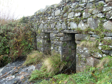 Meengilcarry BridgeBridge · 2.7 mi
Explorer Tom Meengilcarry Bridge crosses a tributary of its namesake river on three low, square-headed spans, built around 1800. Large stone slabs make the clapper-style crossings, with triangular cut-waters on one side. I expected an arch to curve; here the stone goes straight across.
 Cashel Town Wedge TombsWedge tomb · 3.8 mi
Explorer Tom Cashel Town Wedge Tombs are unique because three galleries sit side-by-side in a single circular kerb. One roofstone is four metres long, and locals once found giant human bones here, which is either brilliant or terrifying.
 Wych Elm4.7 mi
Explorer Tom This impressive Wych Elm stands in Donegal, and you might need permission to get a great photo.
 Ginkgo4.7 mi
Explorer Tom This unique Ginkgo in County Donegal is a rare find, so check if you need permission first.
 Killaghtee Old Church GraveyardGraveyard · 5.3 mi
Explorer Tom Killaghtee Old Church Graveyard sits beside the old church; inside the graveyard, southwest of that church, the survey records a cross-inscribed slab. The Civil Survey called the church 'in reparation', and it remained in use until 1826. I like how one small mapped area holds separate records for the graveyard, church and stone.
 John DohertyMemorial · 5.7 mi
Explorer Tom John Doherty’s memorial honors a local hero, standing firm in County Donegal for all who pass by.
 Nancy'sPub · 5.7 mi
Explorer Tom Nancy's is definitely where you go if you want to hear about her ex-husband's horse. The name screams 'local legend' energy. Ask them who broke the window in 1992.
 Doherty'sPub · 5.7 mi
Explorer Tom Doherty's smells like old boots and fresh Guinness mixed together. I reckon the floorboards are sticky from decades of spilled stout. Don't slip on the way out!
More mountains and hills in County Donegal · All of County Donegal

What do you know about this place?Tap to add a comment or ask a question