
Places near here
Photo credits
- Kenneth Allen, Wikimedia Commons · CC BY-SA 2.0
- National Inventory of Architectural Heritage
- Kenneth Allen, Geograph · CC BY-SA 2.0
- Eric Jones, Geograph · CC BY-SA 2.0
- Rossographer, Geograph · CC BY-SA 2.0
- Kieran Evans, Geograph · CC BY-SA 2.0
- N Chadwick, Geograph · CC BY-SA 2.0
- louise price, Geograph · CC BY-SA 2.0
- Joseph Mischyshyn, Wikimedia Commons · CC BY-SA 2.0
 Cairn, LoughanurePublicly named cairn · 3.5 mi
Explorer Tom Cairn, Loughanure is a place where the name suggests a connection to water and perhaps a specific local story. I imagine it’s one of those spots that has been part of the landscape for a long time, maybe used by people who lived nearby. It’s a name that makes you think about how places get their names.
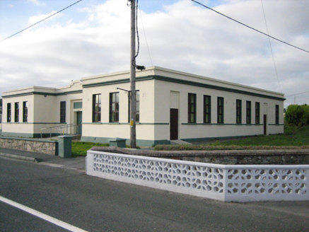 Coláiste MhuireSchool · 3.5 mi
Explorer Tom Coláiste Mhuire in Loughanure was built between 1936 and 1938 as a nine-bay, H-shaped technical school. Its entrance panel reads 'Ceárd Scoil'. I thought the H belonged on a chalkboard; this low, flat-roofed building drew it at full size.
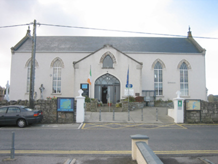 Ionad Teampeall ChróineChurch/chapel · 3.6 mi
Explorer Tom Ionad Teampeall Chróine is a cruciform-plan church from c. 1855-6 that’s now trading its pews for library shelves and heritage displays. It was built by local parishioners who literally raised the stones themselves, which is a level of dedication that really sets it apart. Now that it’s a tourist office, you can peek inside and see how they managed to keep those Celtic cross finials looking so sharp despite the change of use.
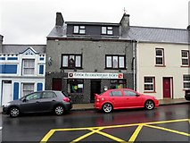 Teach Owenie BánPub · 3.6 mi
Explorer Tom Teach Owenie Bán in Dungloe has a sign that’s falling off the wall, which is very on-brand for the pub. The Irish name is fancy, but the pints are likely mediocre. Keep an eye out for ghosts.
 Mulhern’s Corner BarPub · 3.6 mi
Explorer Tom Mulhern’s Corner Bar sits right on Lower Main Street, looking down its nose at everyone else. The corner is probably sharp enough to cut your cheek. Ask if they have any stories about the wall.
 Cairn, Coolvoy, DoocharyPublicly named cairn · 4.1 mi
Explorer Tom Cairn, Coolvoy, Doochary is a name that sounds like it belongs to a place with a lot of local history and stories. I imagine it’s one of those spots where the ground has been used by people for a very long time, maybe for marking boundaries or gathering. It’s a name that makes you curious about what went on there.
 Drumlaghdrid HillMountain / peak · 4.1 mi
Explorer Tom Drumlaghdrid Hill stands in County Donegal with its access details currently unknown. A photograph shows the B7905 road climbing south-eastwards across its flank, six kilometres north of Lettermacaward. It is a bit cheeky for a hill to have such a well-documented road climbing up its side while still keeping its own path a secret!
 Annagary HillMountain / peak · 5.0 mi
Explorer Tom Annagary Hill. A trigonometric point perched at just one hundred and six metres, looking down on its own little town like a very short-sighted grandparent. I reckon the view is mostly rooftops and a bit of sky.
 Braade StrandBeach / strand · 6.8 mi
Explorer Tom “Braade Strand” in County Donegal would bring a massive bucket of sand and a grumpy crab to any party, which honestly sounds like a perfect combo for most gatherings. It’s a stretch of shore where the wind is loud enough to drown out your inner critic and make you feel small and free. Practise your Irish on it, it won't correct you.
 CarrickfinnOfficial bathing water · 7.1 mi
Explorer Tom Carrickfinn brought a beach and then sneaked a meadow in behind it. Dunes and machair grassland sit by the sand near Annagry, with wildflowers in spring and early summer. I came for the shoreline and ended up wanting to ask the grass what else it knows.
 DooeyOfficial bathing water · 7.2 mi
Explorer Tom Dooey seems to have let the Gweebarra estuary and a headland book its two ends. Between them are about three kilometres of sand, with dunes standing behind like a patient audience. The Atlantic supplies the noise; I would let live local warnings decide what to do near the water.
 Inis Mhic an DoirnIsland · 7.6 mi
Explorer Tom Rutland Island was once pitched as the next big fishing town, and I would have invested every imaginary penny in it. William Burton Conyngham set up the planned settlement between Burtonport and Arranmore in the 1780s, renaming Inis Mhic an Doirn for the Duke of Rutland. There were streets, a customs house, barracks and a sail-and-net factory. Then the herring catches fell, the fishery failed in 1793 and dunes swallowed parts of the village. That is a spectacularly quick lesson in not promising the sea will keep an appointment. The island remained inhabited into the 1960s; houses there are now holiday homes. Arrange a permitted boat and confirm landing and return before visiting, and respect private buildings. Look at the dunes with the lost street plan in mind. Sand is a ruthless town planner.
More mountains and hills in County Donegal · All of County Donegal

What do you know about this place?Tap to add a comment or ask a question