What is recorded here
Places near here
Photo credits
- Kenneth Allen, Geograph · CC BY-SA 2.0
- National Inventory of Architectural Heritage
- Kenneth Allen, Wikimedia Commons · CC BY-SA 2.0
- Ross, Wikimedia Commons · CC BY-SA 2.0
- Rossographer, Wikimedia Commons · CC BY-SA 2.0
- Joseph Mischyshyn, Geograph · CC BY-SA 2.0
- Vadim Manuylov, Wikimedia Commons · CC BY-SA 3.0
- C.B.Doak (user Zorba the Geek ), Wikimedia Commons · Public domain
- Rossographer, Geograph · CC BY-SA 2.0
- David Dixon, Geograph · CC BY-SA 2.0
 Mcnulty's BarPub · 266 yd
Explorer Tom McNulty’s Bar is likely full of people who think they’re great at darts. Watch them miss, then laugh quietly so they don’t notice you laughing.
 Rose's BarPub · 319 yd
Explorer Tom Rose's Bar in County Donegal is blooming with potential, or at least it smells like rose water and old beer. Go there if you want to feel pretty and slightly dizzy.
 water pump, outbuilding412 yd
Explorer Tom Water pump, Outbuilding in Creeslough is a tiny stone building with a pointed arch and a blocked side doorway. The old map puts a water pump nearby, so a pump may once have lived here. It seems to be keeping its own job title a secret.
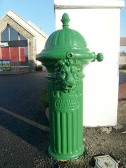 water pump479 yd
Explorer Tom A cheeky cast-iron hydrant in Creeslough, complete with a lion’s head spout and acorn finial, stands proudly as a historic water source.
 Faymore DolmenNamed dolmen · 1.6 mi
Explorer Tom Faymore Dolmen sits right on the roadside with its big capstone perched proudly on upright stones. I can’t find an official number for it, but seeing that massive rock balanced there makes me wonder what story it’s keeping to itself.
 Ards Forest ParkForest recreation place · 2.3 mi
Explorer Tom Ards Forest Park puts four ringfort remains, a holy well and a Mass rock among walks that also reach salt marsh and sand dunes. Ancient stones and sea air make a rather full day here.
 Ballymore Lower Tomb near DunfanaghyMegalithic tomb · 2.9 mi
Explorer Tom Ballymore Lower Tomb near Dunfanaghy offers a massive view toward Muckish Mountain, even if the stones themselves are a bit of a puzzle. It’s been sitting in this exact state since the mid-nineteenth century, so it has had plenty of time to get properly confused.
 Ards Friary Coastal LoopOfficial walking route · 3.2 mi
Explorer Tom We can drive clockwise to enter this friary grounds. Let's take this moderate coastal loop and soak up those historic, salt-air views.
 Monterey Cypress3.3 mi
Explorer Tom Another charming Monterey Cypress in Donegal awaits, so remember to check if permission is needed first.
 MuckishMountain / peak · 3.6 mi
Explorer Tom Well, look at that, Muckish is standing tall in County Donegal, and I heard it looks particularly dramatic from Horn Head. It’s a proper mountain with a bit of mystery to it, so let’s keep our eyes peeled for any hidden paths as we get closer.
 Clonmass IslandIslet · 4.0 mi
Explorer Tom Clonmass Island sits near Little Isle at the north of Clonmass Bay, a place where accurate maps are essential for finding your way.
 Glenveagh National Park Visitor CentreVisitor information · 4.5 mi
Explorer Tom Glenveagh National Park Visitor Centre is located on the eastern side of the Derryveagh Mountains, near the 'glen of birches'.
More wrecks and historic events in County Donegal · All of County Donegal

What do you know about this place?Tap to add a comment or ask a question