
What is recorded here
At the junction of two drainage channels in a flat low-lying waterlogged area of a silted-up lake. Depicted on the 1840 ed. of the OS 6-inch map as a small circle (diam. c. 10m) at the tip of a strip of land jutting into the E part of a lake, in an area that was ‘Liable to Floods’. A subcircular flat-topped mound…
Read the whole record
From the National Monuments Service (Archaeological Survey of Ireland) record CL016-143
Places near here
Photo credits
- Roger Diel, Wikimedia Commons · CC BY-SA 2.0
- Maker not stated on source page, en.wikipedia.org
- Maker not stated on source page, www.tripadvisor.in
- National Inventory of Architectural Heritage
- Maker not stated on source page, ru.pinterest.com
- Maker not stated on source page, www.pinterest.com
- Maker not stated on source page, storage.googleapis.com
- Colin Park, Geograph · CC BY-SA 2.0
- N Chadwick, Geograph · CC BY-SA 2.0
- Andreas F. Borchert, Wikimedia Commons · CC BY-SA 4.0
- Maker not stated on source page, www.dreamstime.com
- Neil Theasby, commons.wikimedia.org
 Caherminnaun Castle (in ruins)Castle, unclassified · 371 yd
Explorer Tom Caherminnaun Castle is basically a heap of rubbish that thinks it's a monument. O’Curry said it was 'a heap of ruins'…
 Fairy fort / stone ringfort in BallykinvargaFairy fort / stone ringfort · 902 yd
Explorer Tom Fairy fort / stone ringfort in Ballykinvarga has been destroyed, but it still acts tough about it. The hero who saved…
 Fairy fort / stone ringfort in MaryvilleFairy fort / stone ringfort · 905 yd
Explorer Tom Fairy fort / stone ringfort in Maryville is officially 'no longer visible' but we’re gonna pretend it’s just being…
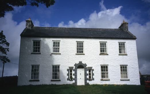 Hollywell HouseFarm house · 1032 yd
Explorer Tom Hollywell House in Maryville, County Clare, had its top floor chopped off around 1910 because it got too tall for its…
 Standing stone in BallykinvargaStanding stone · 1037 yd
Explorer Tom Standing stone in Ballykinvarga was saved by a hero nobody remembers who probably just kicked a rock out of the way…
 Site of Kilcameen ChurchChurch · 1047 yd
Explorer Tom Site of Kilcameen Church has vanished so completely that even the wind can’t find anything to pick on anymore. It’s…
 Fairy fort / stone ringfort in BallyhomultaFairy fort / stone ringfort · 1332 yd
Explorer Tom Fairy fort / stone ringfort in Ballyhomulta is playing hide-and-seek with me. A tale from 1846 says an earl built it…
 Burren Centre KilfenoraVisitor information · 1755 yd
Explorer Tom The Burren Centre in Kilfenora is a sensible first stop before trying to make sense of north Clare's limestone hills. I…
 High CrossHeritage attraction · 1.0 mi
Explorer Tom This High Cross had a moment where a fox took charge of the whole site, sitting on top of it looking like a tiny…
 Saint Fachtnan's CathedralCathedral · 1.0 mi
Explorer Tom Saint Fachtnan's Cathedral in Kilfenora is a Church of Ireland cathedral built from 1170 to 1200, incorporating even…
 Graveyard in KilcarraghGraveyard · 1.3 mi
Explorer Tom Graveyard in Kilcarragh only has one stone, so if you drop your phone there, that’s officially it for the whole place.…
 Kilfenora GAA pitchGAA ground · 1.8 mi
More archaeology and monuments in County Clare · All of County Clare

What do you know about this place?Tap to add a comment or ask a question