Places near here
Photo credits
- National Inventory of Architectural Heritage
- Albert Bridge, Geograph · Creative Commons Attribution-ShareAlike 2.0
- Raymond Okonski, Geograph · Creative Commons Attribution-ShareAlike 2.0
- Raymond Okonski, Wikimedia Commons · CC BY-SA 2.0
- Sebb, Wikimedia Commons · CC BY-SA 3.0
- Karri Huhtanen, Wikimedia Commons · CC BY 2.0
- David Bagshaw, Wikimedia Commons · CC BY-SA 2.0
- Mic from Reading - Berkshire, United Kingdom, Wikimedia Commons · CC BY 2.0
- John O'Beirne, Wikimedia Commons · CC0
- Wingbat, Wikimedia Commons · CC BY-SA 4.0
- Susan Pike, Geograph · CC BY-SA 2.0
- Sarah777 at English Wikipedia, Wikimedia Commons · Public domain
 milestone/milepost387 yd
Explorer Tom This Burrow milestone started because two lads bet five quid that they could find it before the pub closed, and they both lost. It sits there with a benchmark, looking like it knows exactly how much you've underestimated the distance to Howth. Look up, the best bit is always higher than you think.
 Sutton Railway StationSignal box · 411 yd
Explorer Tom The Sutton signal box is tiny, wooden, and currently disused, which makes it feel very abandoned and lonely. Built around 1880, it’s just sitting there on its brick plinth watching nothing happen. Take a pic of the empty view!
 Graveyard in Kilbarrack LowerGraveyard · 980 yd
Explorer Tom Graveyard in Kilbarrack Lower was originally built right on the strand before they walled it off. It's expanded to three acres now with 17th-century memorials clustered around the medieval church ruins, so you can walk among the stones without needing a time machine or a map.
 Kilbarrack CemeteryCemetery · 1009 yd
Explorer Tom Kilbarrack Cemetery is sitting by the sea, which means the wind is always trying to blow your hat off. I’d check if any of the headstones are wearing sunglasses; it gets pretty bright down there.
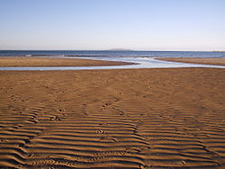 Burrow BeachBeach / strand · 1464 yd
Explorer Tom Burrow Beach has the local name Hole in the Wall, which sounds like a pub I would recommend before checking the sign. It is actually 1.2 kilometres of sand and dunes on the narrow land link between Howth Head and mainland Dublin. Across the inlet you can see toward Portmarnock Strand, so the beach feels less tucked away than its nickname suggests. Summer lifeguards have served it, but check this year's cover and the posted swimming advice; a good name is no safety certificate. You can approach from Burrow Road or walk from Sutton station, which makes it a handy escape without an expedition. Leave the dunes intact and mind other beachgoers while I pretend to identify every distant sail. Come for a short stroll and see how long the view persuades you to stay.
 Corr CastleCastle, tower house · 1.1 mi
Explorer Tom Corr Castle in Howth Demesne is a three-storey tower house with a turret that probably has the best view of the garden party. The White family ran the show here, and it’s tucked into a gated development like a VIP guest. Spot the oldest stone and give it a name.
 Baldoyle Estuary Nature ReserveNature reserve · 1.2 mi
Explorer Tom Baldoyle Estuary Nature Reserve in County Dublin was probably built by a committee that drank exactly three thousand cups of tea before agreeing on a single mudflat. It’s got more wetlands than most people have baths, so don’t expect dry feet. Go back in winter, it's a different animal entirely.
 National Transport MuseumMuseum · 1.6 mi
Explorer Tom National Transport Museum in County Dublin has a 1969 Bedford van that used to carry posts and telegraphs. That is ancient history by vehicle standards! Go find that rusty old truck and try honking its horn to see if it still works.
 Martello Tower1.7 mi
Explorer Tom Martello Tower in Sutton South. Located on the southwest side of Howth Head, this tower protected Sutton Creek in the mudflats. The masonry has been recorded as part of the north Dublin towers. A guardian of the muddy shallows.
 Portal tomb in Howth DemesnePortal tomb · 1.7 mi
Explorer Tom Portal tomb in Howth Demesne is perched right by the golf course, watching the players miss their shots with ancient, stone-faced indifference. I claim it’s actually much older than they think, maybe built by aliens who just wanted a good view of the sea. The roofstone is huge and looks like it’s about to slide off any second now. Make a wish, it's had centuries of practice.
 Dollymount StrandBeach / strand · 1.7 mi
Explorer Tom Dollymount Strand in County Dublin is famous for the ridiculous smuggling story where someone tried to hide a whole van of cheese under the sand. It’s actually where most Dubliners learn to drive, which explains why half the city smells like burnt clutch and fear. Have a wander and a wonder, but keep an eye out for novices who are about to reverse into your foot.
 Shielmartin HillMountain / peak · 1.9 mi
Explorer Tom Shielmartin Hill gives a view towards Howth Head and Dollymount Strand. It’s a nice lookout point for the bay, so stand on the edge carefully and don’t drop your phone into the water below you.
More things to do in County Dublin · All of County Dublin

What do you know about this place?Tap to add a comment or ask a question