What is recorded here
From OpenStreetMap (© OpenStreetMap contributors) n864688336
Places near here
Photo credits
- Kenneth Allen, Wikimedia Commons · CC BY-SA 2.0
- Eric Jones, Wikimedia Commons · CC BY-SA 2.0
- Mike Faherty, Geograph · CC BY-SA 2.0
- Kenneth Allen, Geograph · CC BY-SA 2.0
- Anne Burgess, Wikimedia Commons · CC BY-SA 2.0
- N Chadwick, Geograph · CC BY-SA 2.0
- Yvonne Wakefield, Wikimedia Commons · CC BY-SA 2.0
- Ashishkattoor, Wikimedia Commons · CC BY-SA 4.0
- Ross, Wikimedia Commons · CC BY-SA 2.0
- Cormac Duffin, Geograph · CC BY-SA 2.0
 Sundial HouseHouse · 118 yd
Explorer Tom Sundial House in Cushendall is a charming Grade B1 residence that likely offers lovely views of the surrounding countryside.
 Central BarPublic House · 207 yd
Explorer Tom Central Bar is a Grade B1 pub where stories surely flow as freely as the pint inside.
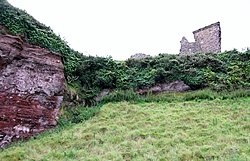 Red Bay CastleArchaeological place · 1.1 mi
Explorer Tom The ruins of Red Bay Castle peek out from the landscape, inviting us to imagine what bustling days once happened here.
 Motte; two baileys; tower-house; curtain wall; possible site of promontory fort: red bay castle in Red BayMotte · 1.1 mi
Explorer Tom Red Bay Castle had a motte, baileys, and walls, making it a complex medieval fortress that probably felt like a whole little village in itself.
 LurigethanMountain / peak · 1.4 mi
Explorer Tom Lurigethan looks east from the Ballyemon Road, a scenic spot in County Antrim for those who wander.
May2007.jpg/250px-Tievebulliagh(AnneBurgess)May2007.jpg "Photo: Anne Burgess, Wikimedia Commons · CC BY-SA 2.0") TievebulliaghMountain / peak · 2.7 mi
TievebulliaghMountain / peak · 2.7 miExplorer Tom Tievebulliagh near Tully features porcellanite outcrops on its slopes, once used to craft ancient stone axes.
 Caves of CushendunHeritage attraction · 3.1 mi
Explorer Tom Peering into the Caves of Cushendun, you might spot a dramatic rock stack just like the ones captured in local heritage photos.
 The White LadyNamed rock · 4.0 mi
Explorer Tom The White Lady is a named rock in County Antrim, an isolated stack on Garron Road resembling a human figure.
 Ess-Na-Crub WaterfallWaterfall · 4.7 mi
Explorer Tom Ess-Na-Crub Waterfall plunges dramatically in County Antrim, its Gaelic name hinting at a wild, ancient, and deeply spiritual local legend.
 Ess-na-Larach WaterfallWaterfall · 4.7 mi
Explorer Tom Ess-na-Larach Waterfall flows gently in County Antrim, perhaps named for the larch trees that once stood tall beside its quiet waters.
 Glenariff ForestWood · 5.0 mi
Explorer Tom Glenariff Forest offers whole views of County Antrim, giving us a perfect chance to soak in the beauty from every single angle.
 Ballypatrick Forest Trails - 1 Cairn TrailWalking route · 5.5 mi
Explorer Tom Step onto the Cairn Trail and ponder ancient double-horned burial sites. History is literally under your feet here!
More viewpoints and information in County Antrim · All of County Antrim

What do you know about this place?Tap to add a comment or ask a question