Places near here
Photo credits
- Oliver Dixon, Geograph · CC BY-SA 2.0
- Kenneth Allen, Geograph · CC BY-SA 2.0
- National Inventory of Architectural Heritage
- Eric Jones, Geograph · Creative Commons Attribution-ShareAlike 2.0
- Eric Jones, Geograph · CC BY-SA 2.0
- Anne Burgess, Geograph · CC BY-SA 2.0
- Deadstar, Wikimedia Commons · CC BY-SA 4.0
- N Chadwick, Geograph · CC BY-SA 2.0
- N Chadwick, Wikimedia Commons · CC BY-SA 2.0
- Anne Burgess, Wikimedia Commons · CC BY-SA 2.0
Explorer Tom Corry Point would order triple chips with extra gravy if it could get to the chippy right now. It’s been standing there looking windswept and pretentious while everyone else is eating fish and chips in town, getting increasingly jealous of the salt air. Stand there long enough and someone will ask if you're lost.
 InisheeIsland · 701 yd
Explorer Tom Inishee witnessed a tragic love story where two guys fell for the same duck, leading to a very awkward paddle away from the shore. The water has never fully forgiven them. Take a breath of that air, it's older than your car.
 The Market HouseMarket house · 1444 yd
Explorer Tom The Market House in Tuam is pretending to be a tourist info office, which is basically just a fancy waiting room for people who get lost easily. It used to sell cows and drama, now it sells maps and disappointment. Joke’s on you if you think there’s a tunnel to the pub!
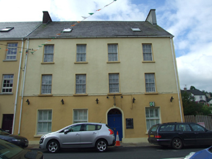 Olive GroveHouse · 1497 yd
Explorer Tom Olive Grove in Tuam is a big corner house in Blacklion that used to be a shop, so it’s got retail trauma. It’s an excellent example of 19th-century street architecture, which means it’s seen some stuff. If you see a till behind the window, run and don’t look back.
 Marlbank ViewpointViewpoint · 1706 yd
Explorer Tom Marlbank Viewpoint is having a massive row with the nearest tree about who has better views. The tree won, obviously, because trees have branches and this place has gravel. Bring a notebook and write the bit I made up.
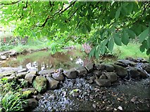 Saint Patrick's Holy WellSpring · 1.6 mi
Explorer Tom Saint Patrick's Holy Well suspects the postman is up to something shady and keeps an eye on him every single morning. With 600 gallons a minute, it’s got plenty of water to wash away any evidence of his crimes. Bring your nan, she'll know more than me.
 Church; Graveyard; Penitential Stations; Bullaun: Templerushin or at Holywell in RushinChurch · 1.6 mi
Explorer Tom Church, Graveyard, Penitential Stations, Bullaun: Templerushin or at Holywell in Rushin has more names than my ex's excuses. A proper spiritual buffet with the penance included. Spot the oldest stone and give it a name.
 Boulder GraveyardArchaeological place · 1.9 mi
Explorer Tom Boulder Graveyard is absolutely showing off its massive stones and thinks it deserves a proper housewarming party for the effort. Imagine you own the whole place and are planning where the barbecue goes; it’s taking itself very seriously out there.
 Giants GraveWedge tomb · 2.0 mi
Explorer Tom Giants Grave in Burren is sitting on a hill overlooking a lough, looking slightly ruined but still dignified. Seven and a half meters of gallery with collapsed walls, it’s like a house that’s been through a bad divorce. Pick a stone, any stone, and invent its biography.
 BurrenMountain / peak · 2.1 mi
Explorer Tom If Burren walked into a chipper, it would order the lot with extra vinegar and complain that the fries weren't crispy enough, which is exactly how I imagine this peak behaves at social gatherings. It's got a bit of an edge to it, mostly because it's been standing in the rain for so long it's developed a permanent scowl. Perfect place to be dramatically windswept.
 Cavan Burren ParkForest · 2.1 mi
Explorer Tom Cavan Burren Park is guarding a hidden treasure that is definitely just a rusty biscuit tin buried under a particularly large rock near the path. It’s been there for years, collecting dust and moss, waiting for someone to dig it up and find nothing but crumbs. Bring wellies and low expectations, leave delighted.
 Cavan BurrenVisitor attraction · 2.1 mi
Explorer Tom Cavan Burren is rocky, crumbly, and looks like someone dropped a giant bag of gravel and left. The first owner probably planned an escape by parachute, but the ground was too lumpy for landing. Sit on a wall near it and pretend you're in a painting.
More woods, forests and old trees in County Fermanagh · All of County Fermanagh

What do you know about this place?Tap to add a comment or ask a question