
Places near here
Photo credits
- National Inventory of Architectural Heritage
- Oliver Dixon, Geograph · CC BY-SA 2.0
- Mick Garratt, Wikimedia Commons · CC BY-SA 2.0
- Oliver Dixon, Geograph · Creative Commons Attribution-ShareAlike 2.0
- Oliver Dixon, Wikimedia Commons · CC BY-SA 2.0
- Colin Park, Geograph · CC BY-SA 2.0
- MickReynolds, Wikimedia Commons · CC BY-SA 4.0
- Britishfinance, Wikimedia Commons · CC BY-SA 4.0
- National Library of Ireland on The Commons, Wikimedia Commons · No restrictions
- Hello, I am Bruce on Flickr, Wikimedia Commons · CC BY-SA 2.0
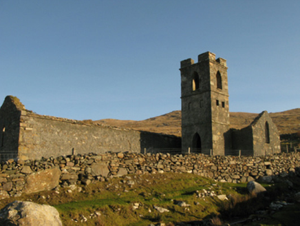 Gowlaun Catholic ChapelChurch/chapel · 1.3 mi
Explorer Tom Gowlaun Catholic Chapel is standing there looking all pious and pointy. It popped up right when Catholics could finally breathe easy in 1829, so it’s probably still feeling smug about the whole thing. The shape is a bit odd, like a cross wearing a hat. Give the spire a wink if you pass by!
 White StrandBeach / strand · 2.0 mi
Explorer Tom White Strand has a name so simple it feels like a cheat code for finding peace, but don’t let that fool you. It’s actually quite intense out there, with the wind screaming like a banshee who lost her keys. Whisper a secret at it when you get there, it's kept worse before.
 Killeen CemeteryGraveyard · 2.2 mi
Explorer Tom Killeen Cemetery over here would absolutely crush it at the county fair if they let dead things compete for best display. Imagine the judges walking past with their clipboards, nodding seriously at the mossy headstones as if they were artisanal cheese wheels on a platter. It’s got that mysterious air that makes you want to check your pocket for a lucky coin, just in case one of them asks for rent.
 KilleenBurial ground · 2.2 mi
Explorer Tom Killeen in Cloonlaur was nearly sold for a horse because nobody could agree on its value. There’s an early Christian slab with crosses that look like they’re judging you. Get there early and have it all to yourself.
 TobernahaltoraWedge tomb · 2.3 mi
Explorer Tom Tobernahaltora in Srahwee took about forty cups of tea to build, according to the local lore that refuses to die. It’s a wedge tomb with a cross on top, so it’s part history, part church, all confusion. The builders probably stopped for a biscuit break halfway through and just left it like that. Dare you to say hello to it out loud.
 Bunlough StrandBeach / strand · 2.4 mi
Explorer Tom Bunlough Strand is what happens when sand, mud, and seaweed have a baby and nobody wants it. It’s known as Killadoon Strand, which sounds more impressive than it actually looks from above. The Vikings supposedly got lost looking for this spot because they couldn't believe how messy it was. Bring a pen pal, they'll be jealous.
 Silver StrandBeach / strand · 2.5 mi
Explorer Tom Silver Strand in County Mayo does some very strange things when nobody’s looking, like rearranging its own pebbles into patterns that look suspiciously like alien hieroglyphics. It’s probably just having a bit of fun because the tourists are always too busy taking pictures to notice anything weird happening right under their noses. The sand is shifting in ways that suggest it’s plotting something.
 IndicatedBridge · 2.6 mi
Explorer Tom Bridge in Roonah is where a ghost got so lazy he just lay down on the arches and napped. The water below has seen better bridges, but this one holds its own with a stubborn sort of grace. It’s not doing much, which is exactly what you want from a bridge on a quiet day. Perfect spot to practise your best tour-guide voice.
 Ben BuryMountain / peak · 3.1 mi
Explorer Tom Ben Bury would cope perfectly on a reality show because it’s dramatic and refuses to share the spotlight. It would probably steal scenes from everyone else just by standing there looking broody in the fog. I’d give it a top ten finish, easily, without even lifting a finger. Grand place for a sulk or a snog, your call.
 MweelreaMountain / peak · 3.4 mi
Explorer Tom Mweelrea is Connacht's highest mountain, and it has no interest in pretending that 814 metres is a casual afternoon. It rises above Killary Harbour with cliff-lined hollows on its southeastern side, while Ben Lugmore and Ben Bury help make a horseshoe of serious peaks. If I call that a neat little loop, take my map away. Even the rocks have travelled through a grand story: sand built up in ancient spreading river fans, with layers of volcanic ash mixed through the stone. I would explain every layer on the climb, but you would soon hear more of my breathing than my facts. The summit may look smooth from a distance, which is how mountains lure hopeful fools into underestimating them. Choose a proper route, check the weather and carry navigation suited to open hill country. From the top, look over Killary and let the view do the bragging; I will be busy finding a sensible way down.
.jpg/250px-Gr%C3%A1inne_Mhaol_Castle_(17087792645).jpg "Photo: National Library of Ireland on The Commons, Wikimedia Commons · No restrictions") O'Malley's CastleCastle · 5.1 mi
O'Malley's CastleCastle · 5.1 miExplorer Tom O'Malley's Castle thinks the local sheep are actually a secret army that just hasn't been mobilised yet. It’s got that defensive look that says it’s ready for trouble but is currently too tired to care. The whole place is just hanging out, waiting for a pirate or a sheep to make a move. Take a breath of that air, it's older than your car.
 Scots Pine5.5 mi
Explorer Tom Scots Pine has a rivalry with a more famous place down the road that gets all the visitors and the photo ops. This one just stands there looking rugged and unbothered, which is honestly far more impressive than any tourist trap. Best enjoyed with a bag of chips and no plans.
More mountains and hills in County Mayo · All of County Mayo

What do you know about this place?Tap to add a comment or ask a question