What is recorded here
From OpenStreetMap (© OpenStreetMap contributors) n5677752087
Places near here
Photo credits
- National Inventory of Architectural Heritage
- Corinna Schleiffer, Wikimedia Commons · CC BY-SA 2.0
- Kenneth Allen, Wikimedia Commons · CC BY-SA 2.0
- Oliver Dixon, Wikimedia Commons · CC BY-SA 2.0
- Attila Terbócs, Wikimedia Commons · CC BY-SA 3.0
- Andreas F. Borchert, Wikimedia Commons · CC BY-SA 4.0
- DAYVEHUSE, Wikimedia Commons · CC BY-SA 4.0
- Kenneth Allen, Geograph · CC BY-SA 2.0
- MoorsoP, Wikimedia Commons · CC BY-SA 4.0
 Clare MountHouse · 1.2 mi
Explorer Tom Clare Mount was built around 1870, replacing an earlier house that stood on the same site. This fine late Victorian residence retains its original form and character, sitting beautifully near Lough Foyle. The render detailing really makes the front elevation pop with visual appeal.
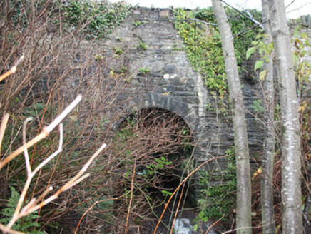 Clare BridgeBridge · 1.3 mi
Explorer Tom Clare Bridge crosses the river on one round arch edged with rock-faced stones and chiselled margins. That masonry resembles Board of Works bridge construction from about 1847 to 1860. The inventory says it may have replaced or heavily altered an earlier bridge shown here in 1837, so the neat arch could hide two building chapters.
 CrockavishaneMountain / peak · 1.4 mi
Explorer Tom We have a whole view of Crockavishane in County Donegal, and I promise the scenery is as lovely as this cheeky explorer’s imagination suggests.
 CroaghmoreMountain / peak · 2.2 mi
Explorer Tom Croaghmore is a big deal in County Donegal, likely the largest peak in the area and a proud landmark for all who see it.
 Old CrossCross, High cross · 2.6 mi
Explorer Tom Old Cross is a stark, undecorated ringed cross standing guard outside the graveyard. It’s over two and a half metres tall but completely plain, which makes it feel like a silent sentinel watching over St. Patrick’s ancient foundations.
 Cooley CrossMemorial · 2.6 mi
Explorer Tom Cooley Cross stands proudly in Moville, a silent guardian watching over the winds of County Donegal.
 Cooly Cat's Eyes Cross SlabCross-slab · 2.6 mi
Explorer Tom Let’s take a look at the Cooly Cat's Eyes Cross Slab, which is famously known locally by that nickname. It’s a broken upright slab with a ringed cross carved in relief, located in the western part of this graveyard traditionally claimed to have been founded by St. Patrick.
 Cooly GraveyardGraveyard · 2.6 mi
Explorer Tom Cooly Graveyard held an unusual find during a cleanup in 2010: half a millstone near the east wall. The record says it may have served as a headstone; its original mill has not been located either. I love that one stone brings two questions here, but neither possibility is certain.
 Quigley's PointHeadland · 4.8 mi
Explorer Tom Near Quigley's Point, United States Navy seaplanes flew from a Lough Foyle base in 1918. It closed by February 1919, after crews had built roads, hangars and slipways; quite a lot of building for such a short stay.
 Inishowen Maritime Museum and PlanetariumMuseum · 5.7 mi
Explorer Tom Inishowen Maritime Museum and Planetarium puts the sea and sky under one old Coast Guard roof in Greencastle. I would happily spend a day moving from fishing boats to the stars. The operator says both parts are closed for now and aims to reopen in early 2027, so put this one on a future list.
 GreencastleCastle · 6.1 mi
Explorer Tom Greencastle was built in 1305 to hold down the North West. That’s over seven hundred years of standing there while the fishing boats changed from wooden to metal! I bet it’s still listening for the clank of old swords.
 Greencastle / Northburgh CastleCastle, Anglo-Norman masonry castle · 6.1 mi
Explorer Tom Greencastle / Northburgh Castle was built by the Red Earl in 1305 to guard the shore, and it’s still standing tall on its rocky perch. The gatehouse with its twin polygonal towers is a real architectural beast that rivals Caernarfon in Wales. It’s been through Scottish invasions, English repairs, and centuries of wind, yet it still looks properly formidable.
More mountains and hills in County Donegal · All of County Donegal
What do you know about this place?