
What is recorded here
Detached three-bay two-storey over basement house, built c. 1870, with single-storey return to rear. Pitched natural slate roof with clayware ridge tiles, smooth rendered decorative gable ended chimneystacks with moulded cornice coping over smooth rendered plinths; moulded stringcourse below paired decorative timber…
Read the whole record
From the Buildings of Ireland (National Inventory of Architectural Heritage) record 40902132
Places near here
Photo credits
- National Inventory of Architectural Heritage
- Corinna Schleiffer, Wikimedia Commons · CC BY-SA 2.0
- danny kearney, Wikimedia Commons · CC BY-SA 2.0
- Oliver Dixon, Wikimedia Commons · CC BY-SA 2.0
- Attila Terbócs, Wikimedia Commons · CC BY-SA 3.0
- DAYVEHUSE, Wikimedia Commons · CC BY-SA 4.0
- Kenneth Allen, Geograph · CC BY-SA 2.0
- Kenneth Allen, Wikimedia Commons · CC BY-SA 2.0
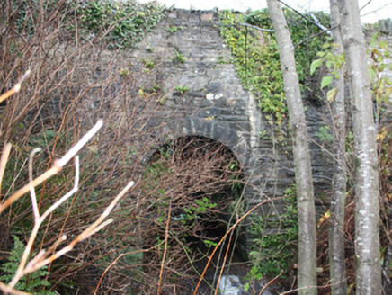 Clare BridgeBridge · 608 yd
Explorer Tom Clare Bridge crosses the river on one round arch edged with rock-faced stones and chiselled margins. That masonry resembles Board of Works bridge construction from about 1847 to 1860. The inventory says it may have replaced or heavily altered an earlier bridge shown here in 1837, so the neat arch could hide two building chapters.
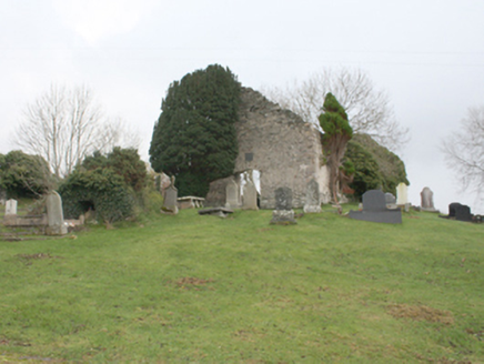 Old Redcastle Church of Ireland ChurchChurch/chapel · 1262 yd
Explorer Tom Old Redcastle Church of Ireland Church was built in 1747 by a Colonel and his crew, yet it's now just a roofless skeleton. Those maritime gravemarkers out front are the real stars, whispering about sailors who never came home. It’s a bit of a sad spot, but you can still feel the weight of two centuries of prayers here.
 CrockavishaneMountain / peak · 2.2 mi
Explorer Tom We have a whole view of Crockavishane in County Donegal, and I promise the scenery is as lovely as this cheeky explorer’s imagination suggests.
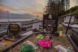 Drung GraveyardBurial ground · 2.3 mi
Explorer Tom Drung Graveyard sits on a plateau above Lough Foyle, hiding the ghost of an old ringfort. The earthworks are mostly gone under the headstones, leaving just faint curves to the north and east. It’s a layer cake of history that time has flattened out.
 Old CrossCross, High cross · 2.3 mi
Explorer Tom Old Cross is a stark, undecorated ringed cross standing guard outside the graveyard. It’s over two and a half metres tall but completely plain, which makes it feel like a silent sentinel watching over St. Patrick’s ancient foundations.
 Cooley CrossMemorial · 2.3 mi
Explorer Tom Cooley Cross stands proudly in Moville, a silent guardian watching over the winds of County Donegal.
 Cooly GraveyardGraveyard · 2.3 mi
Explorer Tom Cooly Graveyard held an unusual find during a cleanup in 2010: half a millstone near the east wall. The record says it may have served as a headstone; its original mill has not been located either. I love that one stone brings two questions here, but neither possibility is certain.
 Barrons CafeCafé · 2.9 mi
Explorer Tom Barrons Cafe serves international food, which usually means pasta with a side of confusion. Grab a slice of pizza and pretend you know what ‘international’ really means here.
 Rosato’sPub · 3.0 mi
Explorer Tom Rosato’s is on Malin Road, which sounds like a road for people who are lost. Tell them Tom sent you and expect a stare that could peel paint off the walls.
 CroaghmoreMountain / peak · 3.0 mi
Explorer Tom Croaghmore is a big deal in County Donegal, likely the largest peak in the area and a proud landmark for all who see it.
 Quigley's PointHeadland · 4.4 mi
Explorer Tom Near Quigley's Point, United States Navy seaplanes flew from a Lough Foyle base in 1918. It closed by February 1919, after crews had built roads, hangars and slipways; quite a lot of building for such a short stay.
 Inishowen Maritime Museum and PlanetariumMuseum · 5.4 mi
Explorer Tom Inishowen Maritime Museum and Planetarium puts the sea and sky under one old Coast Guard roof in Greencastle. I would happily spend a day moving from fishing boats to the stars. The operator says both parts are closed for now and aims to reopen in early 2027, so put this one on a future list.
More historic places in County Donegal · All of County Donegal

What do you know about this place?Tap to add a comment or ask a question