Places near here
Photo credits
- Hywel Williams, Geograph · Creative Commons Attribution-ShareAlike 2.0
- National Inventory of Architectural Heritage
- The original uploader was Ww2censor at English Wikipedia ., Wikimedia Commons · CC BY-SA 2.0
- kevin higgins, Geograph · CC BY-SA 2.0
- Maker named on the Wikimedia Commons picture page · CC BY-SA 3.0
- Mac McCarron, Geograph · CC BY-SA 2.0
- Willow, Wikimedia Commons · CC BY 2.5
- Andreas F. Borchert, Wikimedia Commons · CC BY-SA 4.0
- Matthew Chadwick, Geograph · Creative Commons Attribution-ShareAlike 2.0
- N Chadwick, Geograph · Creative Commons Attribution-ShareAlike 2.0
- Jonathan Thacker, Geograph · CC BY-SA 2.0
- Photo-raven, Wikimedia Commons · CC BY-SA 4.0
 Mount Melleray MonasteryOfficially recorded historic building · 32 yd
Explorer Tom Mount Melleray Monastery in Mountmelleray had a fiddler who played all night until the monks gave up on silence. The seminary part is older and cooler, overshadowed by the bigger abbey but full of quiet rebellion. If you hear faint music from the walls, don’t worry; it’s just the ghost of that stubborn musician warming up.
 GlenshelaneUnknown · 2.0 mi
Explorer Tom Glenshelane is muddling through its identity crisis in Lyre East, acting like a windmill one minute and a memorial the next just to keep everyone guessing. It’s dishevelled, sure, but that romantic messiness is doing it more than any tidy tower could. Keep your eyes peeled for a ghost taking a nap on that crumbling ledge!
 KnockmealdownMountain / peak · 3.7 mi
Explorer Tom Knockmealdown stands on a county border and still manages to keep the actual highest point for Waterford. Its ridge divides Waterford from Tipperary, with routes from the Vee Gap and the Sugarloaf side. The Irish name may refer to the Muldowney family, though other explanations have been offered, so I will not invent a long-lost king just to sound impressive. The open slopes can look friendly from the road, then greet you with wind and bog. I would set off promising a quick loop and be sent back to check my map. Use a lawful established route, read the forecast and take proper navigation and clothes before climbing. Pause at the Vee and see how the ridge shapes both counties. A map line is neat; the mountain that carries it is anything but.
 KnockmoylanMountain / peak · 4.2 mi
Explorer Tom Knockmoylan gets picked on by the wind because it has slightly better ears than its neighbors and hears all the gossip. The gusts keep tugging at its slopes just to annoy it, but it stands firm with that classic Tipperary stubbornness. Bring someone who'll believe anything.
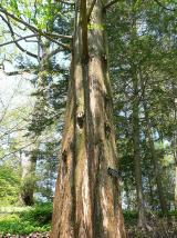 Dawn Redwood4.4 mi
Explorer Tom Dawn Redwood in County Waterford has that prehistoric vibe going on, like it’s seen dinosaurs and wasn’t impressed by them either. There’s a bird up top that refuses to leave, probably because the tree is its only valid excuse for napping. Visit, then text me what you think. I'll pretend to read it.
 Lady Louisa's WalkWalking route · 4.4 mi
Explorer Tom Lady Louisa's Walk would order extra ketchup and a side of attitude if it went to a chippy, demanding her chips be perfectly crispy and her tea scalding hot. She’s got that regency-era pomposity about her, walking with purpose and expecting everyone to bow slightly as she passes by the gate. If it rains, blame me.
 European ash4.5 mi
Explorer Tom European ash in County Waterford is probably hearing everything from the seagulls, who seem to use it as their main gossip station. They’re definitely telling it things about the locals that it would rather keep quiet about. Dare you to say hello to it out loud.
 Cathedral4.5 mi
Explorer Tom Cathedral in Lismore smells like old prayers and expensive regret if you ask me. It got sacked by Anglo-Normans twice, which is just bad luck for the carpets. A good place to forget your phone for ten minutes.
 Lismore CastleOfficially recorded historic building · 4.5 mi
Explorer Tom Lismore Castle would complain to the council that its seventeenth-century fabric is getting too much attention from tourists who don't know how to walk. It’s got medieval towers that are basically just standing there judging everyone else's renovations. Why this place matters: it's tall, you idiot.
 St. Carthaghs WellHoly well · 4.6 mi
Explorer Tom St. Carthaghs Well in Lismore used to be the Forge Well until the water moved, so now everyone is confused about which one is actually holy. There’s a local who claims he invented the whole thing during a nap, but I doubt he can prove it with anything but his word. Look serious, nod slowly, you're basically an expert now.
 Ambrose Power MemorialMemorial · 4.7 mi
Explorer Tom Ambrose Power Memorial in County Waterford stands at a busy junction where traffic goes faster than his escape plan could ever hope to match. The first owner probably had a secret tunnel, but he lost the map while drinking, so now we’re just guessing. Get a photo with it before it gets a better agent who knows what to do with all that stone.
 Ballysaggartmore TowersHeritage attraction · 5.3 mi
Explorer Tom The gates at Ballysaggartmore arrived dressed for a palace. The house did not. Ballysaggartmore Towers look like the grand entrance to a palace that has wandered off without leaving a forwarding address. Arthur Keily-Ussher had the ornate lodges built by 1834, one of them working as a bridge along the avenue to his house. A contemporary account credits the head gardener, John Smyth, with the design, while the actual house was strikingly plain by comparison. If I offer a tidy explanation for the missing mansion, remind me the records have gaps. Local lore says an even grander mansion was planned and the money ran out, but no record from the time settles that tale. Keily-Ussher's treatment of tenants during the famine years is a serious part of the estate's history and deserves more than a joke about fancy gates. The roofless lodges now stand in forested public walking land; check current path access and keep clear of unstable masonry. Admire the stone fantasy, and remember whose work and land lay behind it.
More memorials and graveyards in County Waterford · All of County Waterford

What do you know about this place?Tap to add a comment or ask a question