Places near here
Photo credits
- Jtonra, Wikimedia Commons · CC BY-SA 4.0
- Andreas F. Borchert, Wikimedia Commons · CC BY-SA 4.0
- Humphrey Bolton, Geograph · CC BY-SA 2.0
- National Inventory of Architectural Heritage
- P L Chadwick, Wikimedia Commons · CC BY-SA 2.0
- Mac McCarron, Geograph · CC BY-SA 2.0
- Martin Kerans, Geograph · CC BY-SA 2.0
- Adrian King, Geograph · CC BY-SA 2.0
- Bob Jones, Geograph · CC BY-SA 2.0
- Joseph Mischyshyn, Geograph · CC BY-SA 2.0
- C Michael Hogan, Geograph · CC BY-SA 2.0
 Dermot and Granias BedWedge tomb · 1432 yd
Explorer Tom Dermot and Granias Bed in Creevagh is where two legends went to sleep and never woke up, probably because the mattress was terrible. Tell me if the gossip I made up is true.
 CarnWedge tomb · 1631 yd
Explorer Tom Carn in Parknabinnia is a wedge tomb that people keep calling a cromlech, which is annoying. It’s basically a stone triangle with commitment issues. Make a wish, it's had centuries of practice.
 Burren National ParkVisitor information · 1.7 mi
Explorer Tom Burren National Park is a wild sanctuary where nature's secrets are waiting to be discovered in County Clare
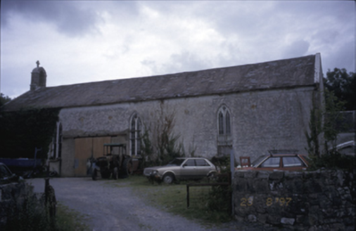 Saint Joseph's Catholic ChurchChurch/chapel · 1.7 mi
Explorer Tom Saint Joseph's Catholic Church in Killinaboy is now an outbuilding, which means its New Year’s resolution was to stop being holy and start storing things. It’s got a square-headed opening from 1975 that looks like a yawn. Spot the oldest stone and give it a name like 'Grumpy'.
 Killinaboy Round TowerVisitor attraction · 1.8 mi
Explorer Tom Killinaboy Round Tower has me thinking it’s a tower that’s as old as the name suggests, but I’m still in doubt.
 Kilinaboy Church (in ruins)Church · 1.8 mi
Explorer Tom Kilinaboy Church holds a fake world record for being the most photogenic ruin in County Clare, according to its own PR team. It was founded by Iníon Baoith, so it's got serious saint-cred going on. Great spot to propose. Or at least to propose lunch before you do.
 Castle in ruinsCastle, tower house · 2.1 mi
Explorer Tom Castle in ruins near Carran Turlough is secretly proud of the potato growing next to its foundation because the castle is doing worse. It controls a routeway but mostly just controls your sense of direction. Pretend it's yours and plan the housewarming.
 Leamaneh Castle (in ruins)Castle, tower house · 2.6 mi
Explorer Tom Leamaneh Castle in Leamaneh North is showing off its five-storey ego again, thinking it’s too good for the locals. It needs a better agent before it ends up in a tourist brochure, so get a photo with it first.
 Inchiquin IslandIslet · 3.0 mi
Explorer Tom Inchiquin Island! A small islet with a name that sounds like it could be part of a royal lineage, what secrets does it keep in County Clare?
 Rock IslandIsland · 3.1 mi
Explorer Tom Rock Island, with its rugged silhouette, stands proudly near Lough Inchiquin’s southern shore.
 Poulnabrone - Burren GeositeVisitor information · 4.3 mi
Explorer Tom Poulnabrone - Burren Geosite has me thinking it's a place where the earth has a special shape; the account doesn't say what's special about it.
 The Portal TombVisitor information · 4.4 mi
Explorer Tom The Portal Tomb has me checking the name twice; the account will not tell me if a rat ever set paw here
More caves in County Clare · All of County Clare

What do you know about this place?Tap to add a comment or ask a question