Places near here
Photo credits
- Keith Cunneen, Geograph · Creative Commons Attribution-ShareAlike 2.0
- Neville Goodman, Wikimedia Commons · CC BY-SA 2.0
- Mike Edgar Kerry, Wikimedia Commons · CC BY-SA 4.0
- Colin Park, Wikimedia Commons · CC BY-SA 2.0
- PAUL FARMER, Geograph · Creative Commons Attribution-ShareAlike 2.0
- Garry Dickinson, Geograph · CC BY-SA 2.0
- Marathon, Geograph · CC BY-SA 2.0
- Goatoo, Wikimedia Commons · CC BY-SA 3.0
- Josh Jackson, Wikimedia Commons · CC BY 2.0
- photo taken by SteffenMP ( de:Benutzer:SteffenMP ), Wikimedia Commons · CC BY-SA 3.0
- Rod Allday, Geograph · CC BY-SA 2.0
- Ian S, Wikimedia Commons · CC BY-SA 2.0
 William Scotts WellHoly well · 496 yd
 BeenreaghMountain / peak · 2.7 mi
 Graveyard4.2 mi
 MullaghnarakillMountain / peak · 4.4 mi
 Blackstones BridgeBridge · 4.5 mi
Explorer Tom Blackstones Bridge would tell its younger self to stop worrying about the V-cutwaters and just flow. Four arches of pure confidence stand over the river without a single apology. Get there early and have it all to yourself.
 Glenbeigh TowersCountry house · 5.9 mi
 Mountain StageViewpoint · 6.0 mi
 Rossbeigh BeachBeach / strand · 7.1 mi
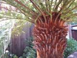 Soft Tree-fern7.5 mi
Explorer Tom This Soft Tree-fern in County Kerry would spend its lotto win on a very expensive haircut. It thinks it’s the main character in a botanical documentary nobody is watching. Stand on the spot and imagine the gossip it's heard.
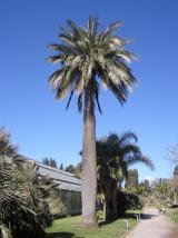 Chilean wine palm7.5 mi
 Kells BeachBeach / strand · 7.7 mi
 Kerry Bog VillageHeritage attraction · 8.0 mi
More mountains and hills in County Kerry · All of County Kerry

What do you know about this place?Tap to add a comment or ask a question