What is recorded here
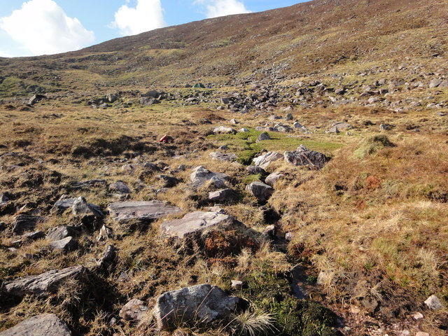
William Scott's Well: This spring well, locally regarded as a holy well, is located high on the NE slopes of Colly mountain just below the old Waterville-Killorglin road. It is a small natural pool from which a stream issues, and is reputedly named after a man who died at this spot (local information). O'Sullivan and J. Sheehan (compilers), 'The Iveragh peninsula: an archaeological survey of South Kerry'. Cork University Press (1996), no. 1066.
From the National Monuments Service (Archaeological Survey of Ireland) record KE081-003
The monument record does not grant public access. Check the route and ask the landowner before entering private land.
- What survives
- Recorded monument
Places near here
Photo credits
- Neville Goodman, Wikimedia Commons · CC BY-SA 2.0
- Mike Edgar Kerry, Wikimedia Commons · CC BY-SA 4.0
- PAUL FARMER, Geograph · Creative Commons Attribution-ShareAlike 2.0
- Colin Park, Geograph · CC BY-SA 2.0
- Garry Dickinson, Geograph · CC BY-SA 2.0
- Marathon, Geograph · CC BY-SA 2.0
- Goatoo, Wikimedia Commons · CC BY-SA 3.0
- Josh Jackson, Wikimedia Commons · CC BY 2.0
- photo taken by SteffenMP ( de:Benutzer:SteffenMP ), Wikimedia Commons · CC BY-SA 3.0
- Ian S, Wikimedia Commons · CC BY-SA 2.0
- Rod Allday, Geograph · CC BY-SA 2.0
 BeenreaghMountain / peak · 2.8 mi
 Graveyard4.4 mi
 Blackstones BridgeBridge · 4.4 mi
 BeannMountain / peak · 4.7 mi
 Glenbeigh TowersCountry house · 6.1 mi
 Mountain StageViewpoint · 6.2 mi
 Rossbeigh BeachBeach / strand · 7.2 mi
 Soft Tree-fern7.7 mi
 Chilean wine palm7.8 mi
 Kerry Bog VillageHeritage attraction · 8.0 mi
 Kells BeachBeach / strand · 8.0 mi
 De Gaulle MemorialMonument · 8.9 mi
More archaeology and monuments in County Kerry · All of County Kerry
What do you know about this place?