
Places near here
Photo credits
- National Inventory of Architectural Heritage
- Pearse MacIntyre, Wikimedia Commons · CC BY-SA 4.0
- MarieDub, Wikimedia Commons · CC BY-SA 4.0
- Andreas F. Borchert, Wikimedia Commons · CC BY-SA 4.0
- National Library of Ireland on The Commons, Wikimedia Commons · No restrictions
- John M, Geograph · CC BY-SA 2.0
- John M, Wikimedia Commons
- Colin Park, Wikimedia Commons
- Donegal Daily (publisher); individual photographer not stated, www.donegaldaily.com
- Einaz80, Wikimedia Commons · CC BY-SA 4.0
 Teachín TessieHouse · 532 yd
Explorer Tom Teachín Tessie has a rounded thatched roof that looks like it’s just dozing off in the Glencolumbkille wind. Built…
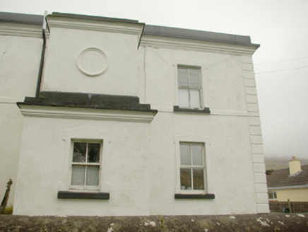 lighthouse keeper's house639 yd
Explorer Tom Lighthouse keeper's house in An Gaineamh Agus An Curraoin looks like a spaceship that crashed into a field of sheep. I…
 Cross-inscribed pillar in An Caiseal (tc Málainn Bhig)Cross-inscribed pillar · 763 yd
Explorer Tom Cross-inscribed pillar in An Caiseal is keeping watch over a subcircular cairn on the rocky floor of Glencolumbkille. I…
 Glencolmcille Old GraveyardGraveyard · 835 yd
Explorer Tom Glencolmcille Old Graveyard holds two church stories: the modern church stands just north of an older church site…
 Eaglais Naomh Columba Eaglais na hÉireannChurch/chapel · 851 yd
Explorer Tom Eaglais Naomh Columba is playing hard to get, claiming its bell tower from 1913 is too fancy to just stand there. It…
 Turas Cholmcille Station 15 CromlechMegalithic tomb · 873 yd
Explorer Tom Turas Cholmcille Station 15 Cromlech is just three stubborn stones standing on a grassy mound near the Murlin River.…
 Cross-inscribed pillar in An TsráidCross-inscribed pillar · 988 yd
Explorer Tom Cross-inscribed pillar in An Tsráid has loops on its face that look like handles for carrying it around. I wonder if…
 Biddy's PubPub · 1039 yd
Explorer Tom Biddy's Pub sits at the crossroads in Glencolumcille, where the music stops and the shouting starts. It claims to be…
 Glencolmcille - Drum LoopOfficial walking route · 1419 yd
Explorer Tom Glencolmcille's Drum Loop gives Donegal's hills a chance to show their sterner side, with a red-arrow climb, boggy…
 Glencolmcille - Tower LoopOfficial walking route · 1419 yd
Explorer Tom Glencolmcille's Tower Loop climbs from a living Donegal village to a coast that looks ready to argue with the Atlantic…
 Páirc na nGael, Naomh ColumbaGAA ground · 1513 yd
 Glencolmcille Folk VillageMuseum · 1.2 mi
Explorer Tom Glencolmcille Folk Village looks like a handful of Donegal cottages stopped for a chat above the sea and forgot to go…
More archaeology and monuments in County Donegal · All of County Donegal

What do you know about this place?Tap to add a comment or ask a question