
Places near here
Photo credits
- National Inventory of Architectural Heritage
- Kenneth Allen, Geograph · Creative Commons Attribution-ShareAlike 2.0
- John M, Geograph · CC BY-SA 2.0
- National Library of Ireland on The Commons, Wikimedia Commons · No restrictions
- Andreas F. Borchert, Wikimedia Commons · CC BY-SA 4.0
- MarieDub, Wikimedia Commons · CC BY-SA 4.0
- Einaz80, Wikimedia Commons · CC BY-SA 4.0
- Ardfern, Wikimedia Commons · CC BY-SA 3.0
- Ben Brooksbank, Geograph · CC BY-SA 2.0
- Kenneth Allen, Geograph · CC BY-SA 2.0
- Michael Murtagh, Geograph · CC BY-SA 2.0
- Michael Earnshaw, Geograph · CC BY-SA 2.0
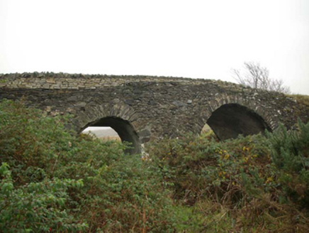 Droichead an tSráidBridge · 209 yd
Explorer Tom Droichead an tSráid crosses the Murlin River on two unequal stone arches, with a pointed cutwater between them. One corner has later repairs. It is a lopsided smile of a bridge, but that middle stone nose still looks ready to part the river.
 Teach Pobail Naomh ColumbaChurch/chapel · 355 yd
Explorer Tom Teach Pobail Naomh Columba in An Caiseal is keeping it simple with those pointed-arch openings that give it a bare minimum Gothic feel. It’s a classic post-Emancipation church from the early nineteenth century, looking almost vernacular. See if you can find any hidden details!
 Biddy's PubPub · 515 yd
Explorer Tom Biddy's Pub sits at the crossroads in Glencolumcille, where the music stops and the shouting starts. It claims to be older than the stones outside, which is definitely a stretch but who’s checking? Stand still and listen, the wind tells it better than me.
.jpg/250px-Pillar_cross_at_Glencolmcille_aka_Glencolumbkille_in_Donegal_(8735027634).jpg "Photo: National Library of Ireland on The Commons, Wikimedia Commons · No restrictions") Cross-inscribed pillar in An TsráidCross-inscribed pillar · 542 yd
Cross-inscribed pillar in An TsráidCross-inscribed pillar · 542 ydExplorer Tom Cross-inscribed pillar in An Tsráid has loops on its face that look like handles for carrying it around. I wonder if someone tried to lift this slab and got tangled up in its own patterns.
 Turas Cholmcille Station 15 CromlechMegalithic tomb · 625 yd
Explorer Tom Turas Cholmcille Station 15 Cromlech is just three stubborn stones standing on a grassy mound near the Murlin River. You can trace the path of St Colmcille here, and there's even a little dry-stone patch where priests used to celebrate Mass. It’s a bit ruined, but it’s still a proper spiritual stop.
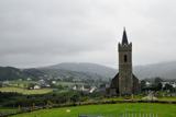 Glencolmcille Old GraveyardGraveyard · 652 yd
Explorer Tom Glencolmcille Old Graveyard holds two church stories: the modern church stands just north of an older church site, whose building was pulled down in 1828. I spotted a useful caution in the record too: earlier writers mentioned a circular enclosure, but the later survey saw no trace. One dot, several layers, and not all equally certain.
 Glencolmcille Folk VillageMuseum · 693 yd
Explorer Tom Glencolmcille Folk Village lines up Donegal homes from the 18th, 19th and 20th centuries in replica cottages. I could walk from one period to another before my tea went cold, though the furniture would change on me at every door. It is a clever way to compare ordinary lives.
 Rossan PointHeadland · 2.6 mi
Explorer Tom Rossan Point wants 'Best Ever Headland' engraved on its tombstone, but also 'Please Stop Parking There'. It’s got very specific instructions for the afterlife. Ideal for a moody photo that you’ll pretend wasn’t actually posed by me telling you to stand there.
 Malin Beg HostelHostel · 3.5 mi
Explorer Tom Malin Beg Hostel sounds like a place where backpackers trade stories that sound more like horror films than holidays. Ask about the strangest guest they’ve ever had, then imagine its imaginary fan club. Go now, before it gets famous.
 Silver Strand ViewpointViewpoint · 3.5 mi
Explorer Tom Silver Strand Viewpoint in County Donegal gave up chocolate for Lent but kept its salt air, which is basically the same thing. Dare you to say hello to it out loud and see if it blushes.
 Slieve LeagueMountain / peak · 4.0 mi
Explorer Tom Slieve League is recorded as a mountain / peak in County Donegal, and its Irish name means 'Mountain of the flagstones'. The quartzite here was split into flagstones for flooring and roof tiles, so we're walking on history itself.
 Slieve League se TopMountain / peak · 4.4 mi
Explorer Tom Slieve League SE Top is recorded as a mountain / peak in County Donegal, featuring an almost flat summit area. It leads to the narrow arete known as One Man's Pass, so keep your footing steady and your nerves calm.
More walking routes in County Donegal · All of County Donegal

What do you know about this place?Tap to add a comment or ask a question