
Places near here
Photo credits
- National Inventory of Architectural Heritage
- Kenneth Allen, Wikimedia Commons · CC BY-SA 2.0
- Kenneth Allen, Geograph · CC BY-SA 2.0
- Richard Webb, Wikimedia Commons · CC BY-SA 2.0
- Rossographer, Geograph · CC BY-SA 2.0
- Michael Murtagh, Geograph · CC BY-SA 2.0
- sarah gallagher, Geograph · CC BY-SA 2.0
- Richard Webb, Geograph · CC BY-SA 2.0
- Somerville, Boyle T. (Henry Boyle Townshend), 1863-1936, Wikimedia Commons · Public domain
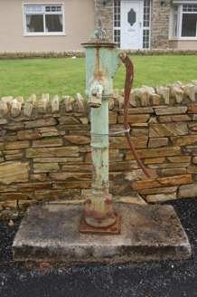 water pump1.2 mi
Explorer Tom Water pump in Tirlaydan has a cow's-tail handle, though the whole thing is cast iron and needs no feeding. Erected around 1900, it recalls the days before mains water reached the area. That handle earns its silly name.
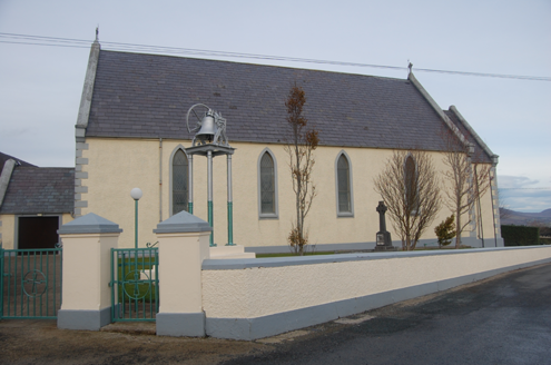 Saint Mary's Catholic ChurchChurch/chapel · 1.3 mi
Explorer Tom Saint Mary's Catholic Church in Tirlaydan was built in 1862 with tall pointed windows and a bronze bell on a separate iron stand. The chancel gained a three-light stained-glass window around 1943. I expected the bell up in a tower; it has its own little place on the ground.
 Drumfad Lower Standing StoneStanding stone · 1.6 mi
Explorer Tom This standing stone in Drumfad Lower used to stand proudly on a ridge with sweeping views of Trusk More, though it did take a tumble during a storm back in 1998. After a rescue excavation to uncover its original socket pit, it was carefully re-erected so it could keep watch over the plateau.
 The Village InnPub · 1.8 mi
Explorer Tom The Village Inn sounds like it contains an actual village, but it’s just a pub on Main Street. Ask the bartender if he knows the local king; he probably doesn’t. Stick around for the light changing, it's a show.
 McGinley'sPub · 1.9 mi
Explorer Tom McGinley's on Main Street has a guy who swears he saw a leprechaun pay his tab. He never left, probably still polishing glasses that aren't there in the back room. Wave at the cows, they're the real locals.
 Ballymastocker StrandViewpoint · 2.4 mi
Explorer Tom Ballymastocker Strand Viewpoint would bring a very aggressive bag of crisps and a blanket with no pattern to any party, just to make sure everyone feels slightly uncomfortable. It’s the kind of place where you stand around wondering if you should be doing something more productive, like swimming, but the wind says otherwise. Grand place for a sulk or a snog, your call.
 Wild Atlantic Way:Ballymastocker StrandVisitor information · 2.4 mi
Explorer Tom Wild Atlantic Way:Ballymastocker Strand in County Donegal would post on social media that it’s 'too majestic for your average selfie stick,' which is exactly the kind of arrogance we’ve come to expect from it. The sand there holds grudges against anyone who digs too deep, and the sign above it looks permanently unimpressed by your efforts. Bring a map, get lost anyway, that's the fun.
 PortsalonOfficial bathing water · 2.6 mi
Explorer Tom Portsalon runs in a wide sandy curve along Lough Swilly, with Knockalla rising behind it. I can almost see a giant pencil trying to draw that line in one stroke. That's the bit that grabs me: sand, water and mountains making one huge sweep, without needing a beauty contest to tell me so.
 Knockalla FortMartello tower and coastal battery · 2.8 mi
Explorer Tom Knockalla Fort guarded the Donegal coast and Lough Swilly during the Napoleonic Wars. Its building record describes a rounded two-storey tower, a dry moat, firing holes and gun mounts on the roof. That is a lot of defence in one place. The record names five other forts nearby; I wonder how their views joined up.
 Rough IslandIslet · 3.2 mi
Explorer Tom Rough Island in Mulroy Bay has made its New Year’s resolution: to be less rude and more reliable. It promises to stay out of the water just once this year, which is a tall order for something that spends half its life underwater sulking. Take the long way round to check if it’s actually trying or just lying through its teeth.
 WoodquarterForest recreation place · 3.7 mi
Explorer Tom Woodquarter would review its visitors by checking if they looked impressed enough at Lord Leitrim’s murder scene from 1878, which is a bit much for a forest walk. The path looks out over Mulroy Bay, giving you a view that makes you forget your phone was missing. A good place to forget your phone for ten minutes.
 Croaghan HillMountain / peak · 3.8 mi
Explorer Tom Croaghan Hill hides a passage tomb that dwarfs its own defensive walls. The enclosure is barely a metre high, yet it shelters a mound three metres high and twenty-one metres across. I bet the ancient builders felt rather small inside their own home.
More mountains and hills in County Donegal · All of County Donegal

What do you know about this place?Tap to add a comment or ask a question