
What is recorded here
Recorded construction date: 1720 - 1739. Current recorded use: Church.
From the Northern Ireland Historic Buildings Record record HB18/17/050
The official record and map point do not grant access. Many historic buildings are privately owned; view them only from public ground unless the owner allows entry.
Places near here
 Clough Non-Subscribing Presbyterian ChurchChurch · 149 yd
 Clough CastleVisitor information · 253 yd
 Motte & Bailey and Tower-house: Clough Castle in CloughMotte & Bailey and Tower-house: Clough Castle · 307 yd
 Clough CastleCastle · 311 yd
 Motte in ArdileaMotte · 1499 yd
 Seaforde Woodland WalkWalking route · 1.4 mi
 Platform rath: savage's fort in MoneycarraghPlatform Rath: Savage's Fort · 1.5 mi
 Castle PathWalking route · 1.9 mi
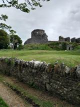 Dundrum CastleHeritage attraction · 2.0 mi
 Church Of The Sacred HeartChurch · 2.0 mi
 Mourne Coastal Route: Dundrum Main StreetVisitor information · 2.1 mi
 Loughinisland massacreMassacre · 3.4 mi
Pictures: Eric Jones, Wikimedia Commons · CC BY-SA 2.0; Eric Jones, Geograph · CC BY-SA 2.0; Man vyi, Wikimedia Commons · Public domain; Eric Jones, Geograph · Creative Commons Attribution-ShareAlike 2.0; Eschadew, Wikimedia Commons · CC BY-SA 4.0; Dean Molyneaux, Wikimedia Commons · CC BY-SA 2.0
More historic places in County Down · All of County Down
What do you know about this place?