What is recorded here
From OpenStreetMap (© OpenStreetMap contributors) w165120852
Places near here
Photo credits
- Anna Maria 4574, Wikimedia Commons · CC BY-SA 4.0
- Alvesgaspar, Wikimedia Commons · CC BY-SA 3.0
- Theresa Bois, Wikimedia Commons · CC BY-SA 4.0
- Sitomon, Wikimedia Commons · CC BY-SA 2.0
- N Chadwick, Wikimedia Commons · CC BY-SA 2.0
- Smirkybec, Wikimedia Commons · CC BY-SA 4.0
- kevin higgins, Geograph · CC BY-SA 2.0
- Andreas F. Borchert, Wikimedia Commons · CC BY-SA 4.0
- Colin Park, Geograph · CC BY-SA 2.0
- kevin higgins, Wikimedia Commons · CC BY-SA 2.0
 Saint Brigid's Catholic ChurchChurch/chapel · 86 yd
Explorer Tom Saint Brigid's Catholic Church in Clonegall has a reredos that looks like it was decorated by a very confused Victorian interior designer. If it's closed, admire it from the road like a polite stalker with a camera and bad manners.
 Saint Fiacc's Church (Moyacomb)Church/chapel · 347 yd
Explorer Tom Saint Fiacc's Church (Moyacomb) in Clonegall is wearing crenellations like a medieval knight who got lost on the way to the office party. It sits in an early Christian churchyard, probably judging your parking job from 1819. Snap one photo, then put the phone away and actually look.
 Common Lime638 yd
Explorer Tom Common Lime tree is just a big green bush that thinks it’s fancy because it has heritage status. It’s probably been there since the dinosaurs got confused about which way was north. Bring a flask and pretend you own the place until someone kicks you out.
 Huntington Castle & GardensHeritage attraction · 758 yd
Explorer Tom Huntington Castle & Gardens is a beautiful heritage attraction, and the castle itself looks absolutely stunning in the photos.
 European Yew803 yd
Explorer Tom This European Yew in County Carlow is watching that ditch where the poet allegedly fell in. He probably tripped over his own ego. Go before the tourists find out and start selling 'Poet's Trip' t-shirts.
 1798 rebellion Battle of Newtownbarry (aka Bunclody) commemorative plaqueMemorial · 2.8 mi
 ToberranananHoly well · 3.1 mi
Explorer Tom Toberrananan is two wells with drystone surrounds, and one had a tree planted over it. That tree was older than most of our problems. Visit, then text me what you think. I'll pretend to read it later.
Battlefield in Ballyprecas,newtownbarryBattlefield · 3.2 mi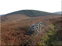 John's HillMountain / peak · 3.7 mi
Explorer Tom John's Hill is shrouded in heathland and forest; at 361m, it’s a great spot to feel small under the vast, open Irish sky.
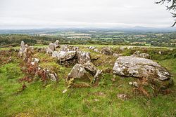 LabbanasigheWedge tomb · 4.0 mi
 Altamont Gardens MapVisitor information · 4.0 mi
Explorer Tom Use the Altamont Gardens Map to navigate the flower borders near Kilbride, Co Carlow, as shown in local photos.
 GreenogeMountain / peak · 4.1 mi
Explorer Tom Greenoge is a peak in County Carlow; the name sounds soft and green, like a gentle hill covered in lush, wild clover fields.
More memorials and graveyards in County Carlow · All of County Carlow

What do you know about this place?Tap to add a comment or ask a question