
Places near here
Photo credits
- National Inventory of Architectural Heritage
- Mike Searle, Wikimedia Commons · CC BY-SA 2.0
- A.-K. D., Wikimedia Commons · CC BY-SA 4.0
- Mike Searle, Geograph · CC BY-SA 2.0
- dougf, Wikimedia Commons · CC BY-SA 2.0
- kevin higgins, Geograph · CC BY-SA 2.0
- Sarah777 at en.wikipedia, Wikimedia Commons · Public domain
- A.-K. D., Wikimedia Commons · CC0
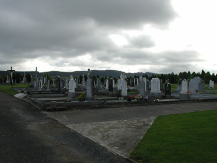 Saint Patrick's Catholic ChurchGraveyard/cemetery · 938 yd
Explorer Tom Saint Patrick’s graveyard in Garranconnell refuses to fall down because it knows it’s got good stories. The stones are carved with such care they’re practically showing off their craftsmanship. Pretend you're a lost aristocrat looking for your ancestral resting place.
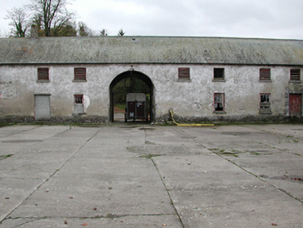 Woodsgift HouseFarmyard complex · 1304 yd
Explorer Tom Woodsgift House farmyard complex holds a long grudge against the weather for burning down its main house in 1914. The remaining quadrangle is just standing there, arms crossed, looking elegant and slightly betrayed. Bring the dog, it'll smell out the history.
_-_geograph.org.uk_-_7541415.jpg/250px-Castles_of_Leinster,_Garryhiggin,_Kilkenny_(2)_-_geograph.org.uk_-_7541415.jpg "Photo: Mike Searle, Wikimedia Commons · CC BY-SA 2.0") CastleCastle, tower house · 1.3 mi
CastleCastle, tower house · 1.3 miExplorer Tom This tower house in Garryhiggin had a massive feud with the next village over something daft, probably about whose sheep looked better on a rainy Tuesday afternoon. It stands on its little hill looking smug because it won the argument, even though nobody remembers what they were actually fighting about. Have a chat with it, nobody's watching.
Kildrinagh WoodForest · 1.7 miExplorer Tom Kildrinagh Wood in County Kilkenny is hosting a dance that definitely went too far, with trees still swaying from the effort. I heard it’s the only place where the floorboards actually remember your steps. Go on, count the windows and get it wrong like I did.
 ToberpatrickHoly well · 2.2 mi
Explorer Tom Toberpatrick in Tubbrid Upper makes a strange bubbling sound at night that locals claim is Patrick talking to his sheep. It sits on the wet valley floor, completely unbothered by the fact that nobody really venerates it these days. A handy spot to stretch your legs and your imagination.
 Tubbrid Castle (in ruins)Castle, tower house · 2.2 mi
Explorer Tom Tubbrid Castle took about four thousand cups of tea to build, according to the locals who were too tired to count properly. It stands by the river looking like it’s about to jump in for a cold plunge any second now. Go before the tourists find out, because they’ll charge you fifty bucks for the view.
KilcooleyForest · 2.4 miExplorer Tom Kilcooley in County Tipperary has a shortcut that goes straight back where you started, which is incredibly rude for a forest to do on purpose. It is basically just trees standing in a circle pretending they are deep thinkers. Bring a notebook and write the bit I made up.
 Sheela-na-gig in Clomantagh LowerSheela-na-gig · 2.4 mi
Explorer Tom Sheela-na-gig in Clomantagh Lower has a local who claims he invented the design himself back in the medieval era. The figure is waving at you with one hand while showing everything else with the other. Take a breath of that air, it's older than your car.
 Wellington MonumentViewpoint · 2.6 mi
Explorer Tom Wellington Monument in County Tipperary was built by Sir William Barker in 1817, but legend says he really just wanted a tall pole to hang his laundry from after Waterloo. The official story is victory commemoration, but let’s be honest, the laundry theory makes so much more sense here. Bring curiosity, leave with a better story than mine.
 Clomantagh HillMountain / peak · 2.8 mi
Explorer Tom Clomantagh Hill has a ghost assigned to it, but he's too lazy to haunt properly, preferring to nap in the shadows instead. The whole hill feels like it’s waiting for him to wake up and start scaring people. Ten minutes here gives you plenty of material for your next pub yarn.
 John HelyMemorial · 3.3 mi
Explorer Tom John Hely Memorial is lying there looking like he's judging your shoe choice from 1803 to now. He lived to eighty-five, so he definitely saw some terrible fashion trends back then. Bring a coin for luck and keep it in your pocket.
DelaneyMemorial · 3.5 miExplorer Tom Delaney in County Kilkenny bragged about surviving a storm so bad it blew the roof off the next village over, which is probably just a tall tale. It's a memorial that has seen things, but mostly just rain and very stubborn weeds growing through its base. Spot the oldest stone and give it a name.
More archaeology and monuments in County Kilkenny · All of County Kilkenny

What do you know about this place?Tap to add a comment or ask a question