
Places near here
Photo credits
- Rod Grealish, Geograph · CC BY-SA 2.0
- National Inventory of Architectural Heritage
- Kenneth Allen, Wikimedia Commons · CC BY-SA 2.0
- Humphrey Bolton, Geograph · CC BY-SA 2.0
- Eric in SF, Wikimedia Commons · CC BY-SA 3.0
- Maker named on the Wikimedia Commons picture page · Public domain
- Jack Bracken, Wikimedia Commons · CC BY-SA 3.0
- Andreas F. Borchert, Wikimedia Commons · CC BY-SA 4.0
- Ross, Wikimedia Commons · CC BY-SA 2.0
- David Dixon, Geograph · CC BY-SA 2.0
 Astelleen Burn WaterfallWaterfall · 1.3 mi
Explorer Tom Astelleen Burn Waterfall is the reward for carrying on beyond Glenveagh Castle when everyone else has decided the…
 Glenveagh CastleCoach house · 1.5 mi
Explorer Tom Glenveagh Castle includes a former coach house built around 1930, with three carriage arches and a crenellated parapet.…
 Walled GardenGarden · 1.6 mi
Explorer Tom Glenveagh's Walled Garden is a rather splendid trick: a kitchen garden tucked into an old quarry behind a castle, with…
 Glenveagh Tea RoomCafé · 1.6 mi
Explorer Tom Glenveagh Tea Room has donuts and bagels that have seen things no pastry should ever see in its life. They close at…
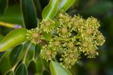 Wheel tree1.6 mi
Explorer Tom Wheel tree is the life of every wedding, standing there in the background looking incredibly dramatic while everyone…
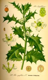 English holly1.7 mi
Explorer Tom English holly in County Donegal had an escape plan involving its berries and a very determined squirrel who never quite…
 monument2.5 mi
Explorer Tom Monument in Lacknacoo stands guard over a spot once labelled as Saint Columbkille's Stone. The 1911 cross by Cornelia…
 Staghall MountainMountain / peak · 2.7 mi
Explorer Tom Staghall Mountain has a proper view captured for us, and it looks like a solid old friend standing up in County…
 Gartan Ráth Cnó Turas 3 CrossCross · 2.8 mi
Explorer Tom Gartan Ráth Cnó Turas 3 Cross is a bit of a ghost, with its arms barely visible on that rocky mound. It’s part of St…
 Gartan Ráth Cnó Turas 5 CrossCross · 2.8 mi
Explorer Tom This is *Gartan Ráth Cnó Turas 5 Cross*, the fifth station of a pilgrimage path where the arms are barely perceptible…
 Glebe House and GalleryHeritage attraction · 3.1 mi
Explorer Tom Glebe House and Gallery has an artist's eye at one end and Lough Gartan trying very hard to outshine it at the other. I…
 Glenveagh National Park Visitor CentreVisitor information · 3.4 mi
Explorer Tom Glenveagh National Park Visitor Centre is where they hand you the keys to the kingdom of birches. It’s the second…
More mountains and hills in County Donegal · All of County Donegal

What do you know about this place?Tap to add a comment or ask a question