What is recorded here
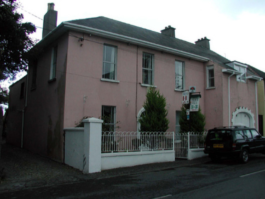
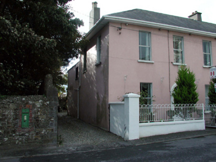
Detached four-bay two-storey house, c.1840, with single-bay single-storey lean-to projecting bay with half-dormer attic to right having elliptical-headed carriageway to ground floor. Extensively renovated and extended, c.1865, comprising single-bay two-storey flat-roofed lower return to south. Reroofed, c.1990, with half-dormer attic remodelled. Now in use as guesthouse. Hipped and pitched roof (continuing into lean-to to projecting end bay) with replacement artificial slate, c.1990, clay ridge tiles, rendered chimney stacks, replacement flat felt roof, c.1990, to half-dormer attic window, and replacement uPVC rainwater goods, c.1990, on replacement uPVC eaves, c.1990. Flat felt roof to return with plastic rainwater goods. Painted rendered walls. Square-headed window openings with rendered sills. Replacement aluminium casement windows, c.1965, having margins with replacement uPVC casement window, c.1990, to half-dormer attic. Round-headed door opening with moulded rendered surround, replacement glazed uPVC panelled door, c.1990, having sidelights, and spoked fanlight. Elliptical-headed carriageway with painted red brick block-and-start surround, and timber boarded double doors. Road fronted with sections of hoop iron railings to front on painted rendered plinth having wrought iron gate, and painted rendered terminating piers.
An appealing house that is distinguished in the streetscape by the unusual feature of a projecting end bay incorporating a carriageway. Although the house retains most of its original form and massing, the inappropriate replacement fittings and materials have noticeably compromised the historic quality of the site. Nevertheless, the house remains an important element of Church Road, the iron gate and railings to the front enhancing the visual appeal of the site.
From the Buildings of Ireland (National Inventory of Architectural Heritage) record 22816009
This does not grant access. Most recorded buildings are privately owned; view them only from public ground unless the owner allows entry.
Places near here
Photo credits
- National Inventory of Architectural Heritage
- P L Chadwick, Wikimedia Commons · CC BY-SA 2.0
- Paul O'Farrell, Geograph · CC BY-SA 2.0
- Tmimagery, Wikimedia Commons · CC BY-SA 4.0
- Brendan Tobin, Wikimedia Commons · CC BY-SA 4.0
- Kieran Campbell, Wikimedia Commons · CC BY-SA 2.0
- P L Chadwick, Geograph · CC BY-SA 2.0
- RTG, Wikimedia Commons · CC BY-SA 4.0
- Philip Halling, Wikimedia Commons · CC BY-SA 2.0
- John M, Geograph · CC BY-SA 2.0
 Historic buildingOfficially recorded historic building · 12 yd
_%5E_Sea_Horse_Obelisk,_Church_Road,_Tramore,_Co._Waterford_-_geograph.org.uk_-_3963489.jpg/250px-Christ_Church_(2)_%5E_Sea_Horse_Obelisk,_Church_Road,_Tramore,_Co._Waterford_-_geograph.org.uk_-_3963489.jpg "Photo: P L Chadwick, Wikimedia Commons · CC BY-SA 2.0") Christ Church (Drumcannon)Church/chapel · 56 yd
Christ Church (Drumcannon)Church/chapel · 56 yd Doneraile WalkWalking route · 283 yd
 Newtown CoveBeach / strand · 1.1 mi
 Tramore StrandBeach / strand · 1.5 mi
 The Metal ManHeritage attraction · 1.6 mi
 Fenor BogNature reserve · 3.0 mi
 Matthewstown Passage TombArchaeological place · 3.3 mi
 Kilfarrasy BeachBeach / strand · 3.6 mi
 Gaulstown Portal TombArchaeological place · 4.0 mi
 Dunhill CastleCastle · 4.6 mi
 Castle (in ruins)Castle, tower house · 4.6 mi
More historic places in County Waterford · All of County Waterford
What do you know about this place?