What is recorded here
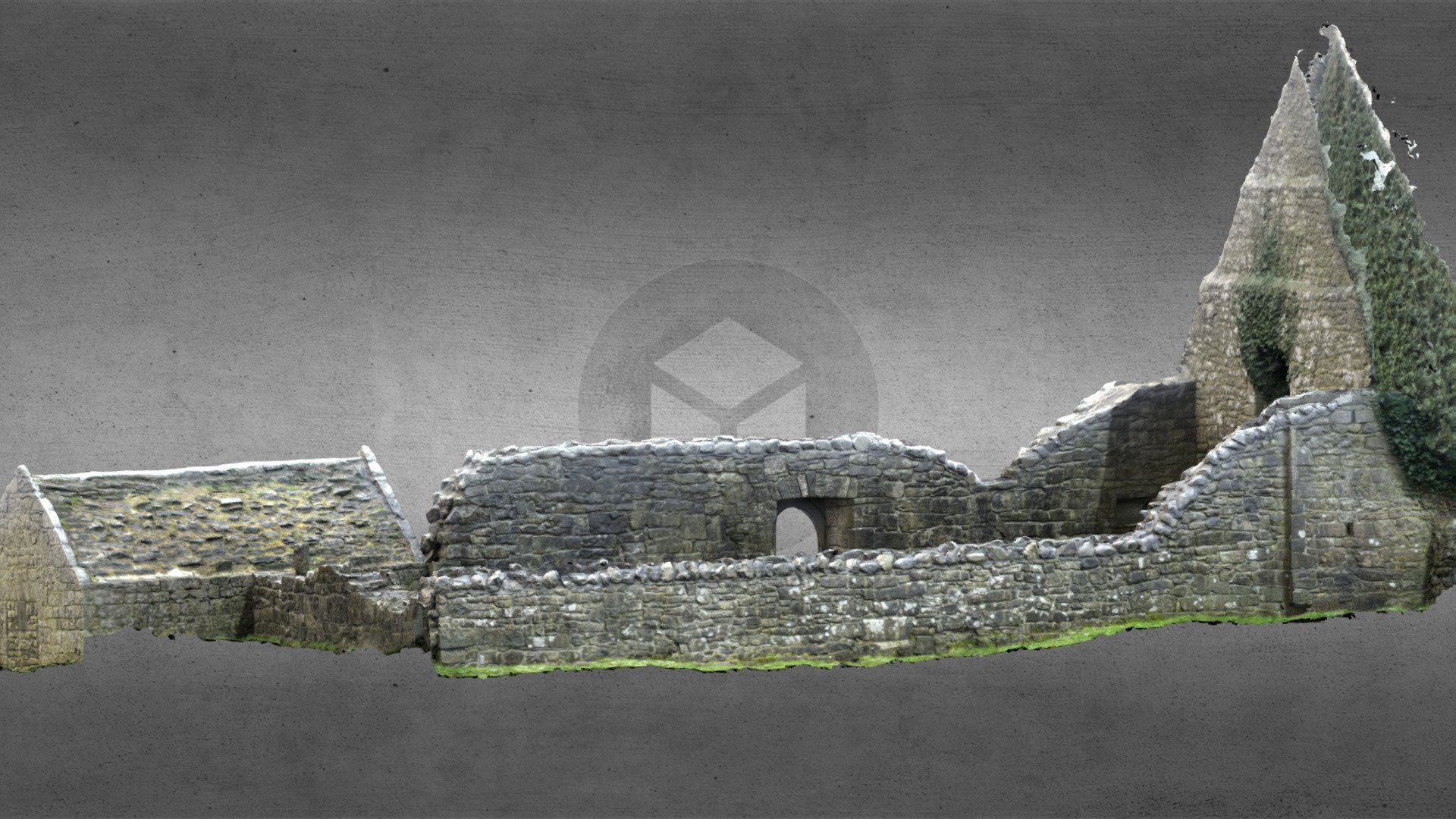
This is the parish church of Taghboy, listed as Techfrick in the ecclesiastical taxation of Elphin in 1306 (Cal. doc. Ire., vol. 5, 224), which is situated on a slight N-facing slope in a low-lying landscape. The church owned the Quarter of Taghboy in 1641 amounting to 209 acres as well as the bog of 827 acres, and retained them through the Cromwellian settlement (Simington 1949, 111). The church is a rectangular structure (ext. dims 14.6m E-W; 8.6m N-S), of which the E wall and much of the N wall do not survive, but a separate chancel may have existed. The base of a doorway is in the centre of the S wall and there is a small light in the W wall with an ogee-headed window above for a gallery. The apex of the gable has a sheela-na-gig (RO044-079006-), which was recovered in excavation (97E0010) by Jim Higgins. There is a single light in the N and S walls at the W end. Fragments of querns, a voussoir with incised decoration and two fragments of a doorway with keel moulding (RO044-079005-) are at the location. The present church is probably 16th-century but incorporates remains of a church of c. 1200.
The church is at the N edge of a D-shaped graveyard (RO044-079002-) (dims c. 50m E-W; c. 30m N-S) with the straight side at N defined by masonry walls, which are on the remains of an earthen bank E-S. A shallow fosse (Wth of top 4-12m; D 0.2-0.9m) can be traced NE-S on the E side of a NNE- SSW public road, while traces of the bank can be detected W-NW, creating an ecclesiastical enclosure (RO044-079004-) (diam. c. 100m E-W), but the perimeter cannot be traced at NW-NE. A bullaun stone (RO044-0790043-) was moved to the Roman Catholic church at Four Roads (RO044-125----), and the church was conserved in the 1990s while the graveyard has been extended to the S. (Beirne 1997b)
See the attached view of the E window (001) and of a decorated voussoir (005)
Compiled by: Michael Moore
Date of upload: 24 August 2010
A local church or high cross; wider significance not recorded.
The monument record does not grant public access. Check the route and ask the landowner before entering private land.
- What survives
- Recorded monument
Places near here
 Ecclesiastical enclosure in TaghboyEcclesiastical enclosure · 10 yd
 Church in Cloghan,curraghadoonChurch · 985 yd
 IndicatedEnclosure · 1521 yd
 Saint Joseph's Catholic Churchchurch/chapel · 2.0 mi
 Inchnaveague IslandIslet · 2.6 mi
 Inch IslandIsland · 2.9 mi
 Site of Ballygar CastleArchaeological place · 4.0 mi
 European Crab AppleEuropean Crab Apple · 4.4 mi
 Castle KellyCastle, tower house · 4.6 mi
 Aughrane WoodsForest · 4.6 mi
 Mount MaryMountain / peak · 7.7 mi
 Kilconnell AbbeyHeritage attraction · 13 mi
Other information
Photo: Credit not shown in the picture search · Rights wording not checked; contact us if this picture should be removed