
What is recorded here
Situated on a knoll in an undulating landscape and at the head of a valley that extends off to the NE. The headwaters of a stream that follows the valley to debouch into Milltown Lough are in the immediate vicinity. This is the parish church of Killane parish, which was dedicated to St. Anne. The parish was broken up in 1778 when most of it became Shercock parish but 29 townlands, including Killan, were joined with others from Moybologe parish to form the parish of Bailieborough (Lewis 1837, vol. 1, 99). During the fifteenth century part of the tithes of the parish were paid to the St Mary’s Augustinian abbey of Kells (ME017-044039-) (Kelly 2017, 35). An effort was made to raise money for its refurbishment as a place of Protestant worship in 1630s (ibid. 292). The remains consist of the NE gable of a rectangular church (ext. dims 22.95m NE-SW; 8.6m NW-SE; int. dims 15.8m NE-SW; 6.23m NW-SE) but most of the long walls are missing, apart from where they are incorporated into a mausoleum at its SW end. There are no surviving quoinstones but the SW wall has a large base-batter. The NE gable has been conserved to the apex with a crudely pointed central window opening (ext. Wth 1m; H 1.8m). The inaccessible barrel-vaulted mausoleum has a NW-SE barrel-vault (int. dims c. 4m NE-SW; 6.25m NW-SE), a light on the SE wall, and a sealed doorway from the nave. This now has a plaque of probable eighteenth century date claiming the vault for the Cosby family. A piece of a window jamb with a rebate for an external shutter is used as a grave-marker in the graveyard. The church is in a circular graveyard (diam. c. 70m NE-SW; c. 65m NW-SE) with few headstones defined by a slight bank with an external stone facing and by a masonry wall at the roadside S-W. A well, which is a natural spring at the base of some rock outcrop is c. 25m outside the graveyard to the NW but there is no indication that it is a holy well. St Anne’s holy well (CV028-028----) is c. 370m to the NE. (Davies 1948, 76)
The above description is derived from the published 'Archaeological Inventory of County Cavan' (Dublin: Stationery Office, 1995).
Situated on a knoll in an undulating landscape and at the head of a valley that extends off to the NE. The headwaters of a stream that follows the valley to debouch into Milltown Lough are in the immediate vicinity. This is the parish church of Killane parish, which was dedicated to St. Anne. The parish was broken up in 1778 when most of it became Shercock parish but 29 townlands, including Killan, were joined…
From the National Monuments Service (Archaeological Survey of Ireland) record CV028-027001
The monument record does not grant public access. Check the route and ask the landowner before entering private land.
- What survives
- Recorded monument
Places near here
 Graveyard9 ydDerrynureMountain / peak · 856 ydNolaghWood · 1216 ydCorravillaMountain / peak · 1365 yd
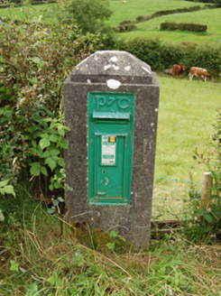 post box1367 yd
 St Anne's Roman Catholic ChurchChurch/chapel · 1.3 mi
 Welcome to Bailieborough DemesneVisitor information · 1.9 mi
 Grave YardGraveyard · 2.8 mi
 Brothers GravesVisitor information · 3.0 mi
 Bush IslandIslet · 3.1 mi
 LoughanleaghForest · 4.3 mi
 Fair of MuffMemorial · 5.4 mi
Pictures: Eric Jones, Geograph · Creative Commons Attribution-ShareAlike 2.0; National Inventory of Architectural Heritage; Kieran Campbell, Geograph · CC BY-SA 2.0; Oliver Dixon, Geograph · CC BY-SA 2.0
More historic places in County Cavan · All of County Cavan
What do you know about this place?