
What is recorded here
Located in a prominent position with land falling gently to W and steeply to S. Church 1st mentioned in early 15th century on the incorporation of a guild 'the guild of the fraternity of Our Lady St Mary of the Church of Mulhuddart (Ball 1920, 44-46). Civil Survey 'walls of a church' at Buzardstown (Simington 1945, 227). Church situated in a raised graveyard which curves alongside W side. Undivided nave and chancel (int. dims. 20.22m wt. 8.73m, h. 0.5m, th. 0.97m-1.2m with residential W tower that survives to the first floor level. Rough coursed shaley limestone with dressed quoins. Vault over ground floor shows traces of wickerwork centering, ext. dimes. 1.745 wt. 4.9m. Ist floor has projecting turret on S side, a window in W and 2 wall recesses in N. Nave is entered through segmental arched opening in N wall. The exterior of the western gable has two mouldings for plaques. The upper is empty, the lower contains an 18th century mural tablet inscribed to Denis Commins & Mary Warren 1675-1740s. Window in south facade of tower appears to have been reinstated. Arch of residential tower subject to burning and graffiti. Gravestones present in interior of church.
Located in a prominent position with land falling gently to W and steeply to S. Church 1st mentioned in early 15th century on the incorporation of a guild 'the guild of the fraternity of Our Lady St Mary of the Church of Mulhuddart (Ball 1920, 44-46). Civil Survey 'walls of a church' at Buzardstown (Simington 1945, 227). Church situated in a raised graveyard which curves alongside W side. Undivided nave and…
From the National Monuments Service (Archaeological Survey of Ireland) record DU013-010001
The monument record does not grant public access. Check the route and ask the landowner before entering private land.
- What survives
- Recorded monument
Places near here
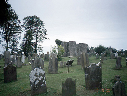 graveyard/cemetery6 yd
 Graveyard in BuzzardstownGraveyard · 21 yd
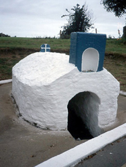 Lady's WellHoly well · 300 yd
 Ladys WellHoly well · 300 yd
 TyrrelstownWood · 823 yd
 MoatMound · 1119 yd
 Church, GraveyardChurch · 2.3 mi
 Dunsink ObservatoryHeritage attraction · 2.6 mi
 Castleknock CastleCastle · 3.0 mi
 Luttrellstown CastleCastle · 3.1 mi
 Giant Sequoia3.1 mi
 Griffeen Valley WalkWalking route · 5.0 mi
Pictures: National Inventory of Architectural Heritage; TeaTimeJ, Wikimedia Commons · CC BY-SA 4.0; Harold Strong, Geograph · CC BY-SA 2.0; Rob Hurson, Wikimedia Commons · CC BY-SA 4.0; JP, Wikimedia Commons · CC BY-SA 2.0; Laurel Lodged, Wikimedia Commons · CC BY-SA 4.0; The British Library, Wikimedia Commons · No restrictions; Mike Murphy ( talk · contribs ), Wikimedia Commons · CC BY-SA 3.0; jwd, Geograph · CC BY-SA 2.0
More historic places in County Dublin · All of County Dublin
What do you know about this place?