
What is recorded here
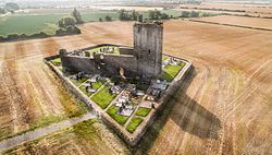
Known locally as Baldongan Castle the church is a National Monument (No. 310) in state care. Located within a walled graveyard (DU005-037002-) on a prominent hill summit. It is a plain well built rectangular building with residential west tower of 15th-century date. It was granted to Kilbixy c. 1190 but by agreement with the bishop money was also paid to the cathedral from this church. In 1630 it was described as being in a ruinous condition needing a roof for many years (Ronan 1941, 70). This is the medieval parish church described in the Civil survey (1654-6) as 'ye walls of ye parish church' (Simington 1945, 67). It has a divided nave and narrower chancel, the division marked by broken masonry or tie - stones (int. dims. Nave 12.70m E-W, 6.85m N-S; Chancel 12.10mE-W, 6.85m N-S). The nave has opposing pointed arched doorways towards W end. There are double-arched recesses on N and S wall of the chancel with a carved shield portraying the crucifixion, altar, candles and angels inset into S recess. The chancel contains an aumbrey in the E wall and remains of a dressed stone window with two plain windows in S wall. The west tower is entered from the nave, through a pointed arched doorway. It is three storeys high, roughly square in plan (3.4m N-S, 3.6m E-W) with projections on N, S and W wall. The stairwell in the W projection is lit by slit opes. Barrel vault over ground floor and timber floor over first floor. The chimney breast in E wall is carried on corbels. Double bellcote over E wall. Traditionally there are views of thirteen counties from the top.
Known locally as Baldongan Castle the church is a National Monument (No. 310) in state care. Located within a walled graveyard (DU005-037002-) on a prominent hill summit. It is a plain well built rectangular building with residential west tower of 15th-century date. It was granted to Kilbixy c. 1190 but by agreement with the bishop money was also paid to the cathedral from this church. In 1630 it was described as…
From the National Monuments Service (Archaeological Survey of Ireland) record DU005-037001
The monument record does not grant public access. Check the route and ask the landowner before entering private land.
- What survives
- Recorded monument
Places near here
 church/chapel1 ydBaldongan ChurchRuins · 2 yd
.JPG/250px-Baldongan_Castle_(exterior).JPG "Photo: Cathalgibbons, Wikimedia Commons · CC BY-SA 4.0") Castle (in ruins)Castle, Anglo-Norman masonry castle · 37 yd
Castle (in ruins)Castle, Anglo-Norman masonry castle · 37 yd Windmill (in ruins)Windmill · 1.6 mi
 Windmill (disused)Windmill · 1.7 mi
 IndicatedCastle, tower house · 1.7 mi
 Skerries BeachVisitor information · 2.2 mi
 Skerries Harbour and BeachVisitor information · 2.2 mi
 Shenick IslandIslet · 2.3 mi
 Graveyard in LuskGraveyard · 2.4 mi
 Thomas AsheMemorial · 2.6 mi
 Rush South BeachBeach / strand · 3.0 mi
Pictures: Broderick Mark, Wikimedia Commons · CC BY-SA 4.0; Cathalgibbons, Wikimedia Commons · CC BY-SA 4.0; Jonjobaker, Wikimedia Commons · CC BY-SA 4.0; Martinvl, Wikimedia Commons · CC BY-SA 4.0; Gallftree008, Wikimedia Commons · CC BY-SA 4.0; Colin Park, Geograph · CC BY-SA 2.0; jai, Wikimedia Commons · CC BY-SA 2.0; JacK93, Wikimedia Commons · CC BY-SA 4.0; FrankFlanagan, Wikimedia Commons · CC0; jwd, Geograph · CC BY-SA 2.0
More historic places in County Dublin · All of County Dublin
What do you know about this place?