What is recorded here
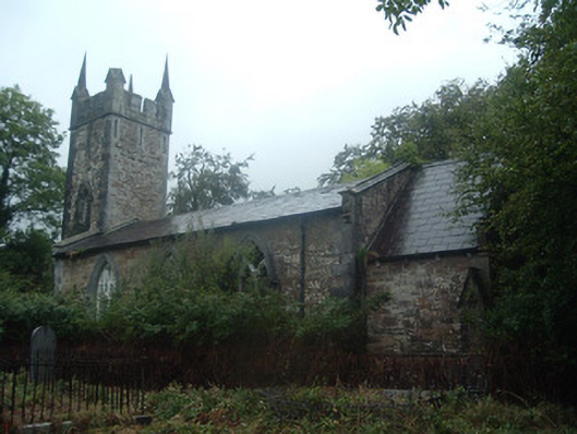
In N half of graveyard, c. 800m E of mining settlement of Dromagh (15253). Built of random ashlar sandstone construction with limestone detail. Rectangular nave (long axis NE-SW), lit by three large pointed windows in S wall with ornate cusped Y-tracery; vestry projects at E end of N wall. Chancel added to E with buttresses on corners. Slim embattled three storey tower with pinnacles to W, angled buttresses on corners, bluntly pointed door in S wall. Erected in 1822 (Lewis 1837, vol. 1, 509); no longer in religious use. Graveyard subrectangular (c. 50m N-S; c. 40m E-W) and tree lined; headstones date from mid-19th century and confined to S of church.
The above description is derived from the published 'Archaeological Inventory of County Cork. Volume 4: North Cork' (Dublin: Stationery Office, 2000). In certain instances the entries have been revised and updated in the light of recent research.
Date of upload/revision: 14 January 2009
The monument record does not grant public access. Check the route and ask the landowner before entering private land.
- What survives
- Recorded monument
Places near here
 church/chapelchurch/chapel · 1 yd
 IndicatedGraveyard · 22 yd
 Castle (Site of)Bawn · 420 yd
 Mine in DucleaghMine · 863 yd
 DromaghMiner's settlement · 912 yd
 Battle of Knocknaclashybattle · 1.4 mi
 Drominagh Castle (Site of)Castle, unclassified · 2.1 mi
 Rathcool WoodWood · 2.7 mi
 Kanturk CastleHeritage attraction · 3.8 mi
 St Fursey's WellSpring · 4.3 mi
 Hanna SheehyMemorial · 4.4 mi
 Mount Hillary - Father Murphy LoopWalking route · 4.7 mi