
What is recorded here
Recorded construction date: 1860 - 1879. Current recorded use: Church.
From the Northern Ireland Historic Buildings Record record HB03/12/001
The official record and map point do not grant access. Many historic buildings are privately owned; view them only from public ground unless the owner allows entry.
Places near here
Photo credits
- Carroll Pierce, Geograph · CC BY-SA 2.0
- N Chadwick, Wikimedia Commons · CC BY-SA 2.0
- D LN, Wikimedia Commons · CC BY-SA 4.0
- Jamesmcsparron, Wikimedia Commons · CC BY-SA 4.0
- Kenneth Allen, Geograph · CC BY-SA 2.0
- Mike Faherty, Geograph · CC BY-SA 2.0
- Kenneth Allen, Wikimedia Commons · CC BY-SA 2.0
- Kenneth Allen, Geograph · Creative Commons Attribution-ShareAlike 2.0
- Shane Killen, Geograph · CC BY-SA 2.0
 Castlerock BeachBeach / strand · 746 yd
 Mussenden TempleEstate Related Structures · 1240 yd
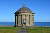 Mussenden TempleHeritage attraction · 1242 yd
 MausoleumMonument · 1307 yd
 Earl Bishop's Tree Trail, DownhillWalking route · 1309 yd
 Church & graveyard in DownhillChurch & Graveyard · 1517 yd
 Downhill BeachVisitor information · 1.1 mi
 St. Mary's rc ChurchChurch · 1.2 mi
 Portstewart StrandBeach / strand · 1.8 mi
 Holy well: tubber patrick in Crossreagh EastHoly Well: Tubber Patrick · 2.6 mi
 Quilley Picnic AreaPicnic place · 2.8 mi
.jpg/250px-Portstewart_Town_Hall_(geograph_3791188).jpg "Photo: Kenneth Allen, Wikimedia Commons · CC BY-SA 2.0") Town HallLibrary · 3.1 mi
Town HallLibrary · 3.1 miMore historic places in County Derry · All of County Derry
What do you know about this place?