What is recorded here
In pasture, amongst rock outcrops, on a S-facing slope of the Ox Mountains. Two blocked-up openings, c. 10m apart, are visible in an E-W line and according to local information there is an 'underground chamber' beneath them.
From the National Monuments Service (Archaeological Survey of Ireland) record SL031-026
The monument record does not grant public access. Check the route and ask the landowner before entering private land.
- What survives
- Recorded monument
Places near here
Photo credits
- Gordon Hatton, Geograph · CC BY-SA 2.0
- National Inventory of Architectural Heritage
- Richard Webb, Geograph · CC BY-SA 2.0
IndicatedFairy fort / stone ringfort · 722 ydTawnyart WoodWood · 1391 ydIndicatedFairy fort / earthen ringfort · 1.1 miNew WoodWood · 1.2 mi Mass RockNamed rock · 2.2 miCloonacoolMountain / peak · 2.5 miCastle Carragh in RuinsCastle, unclassified · 2.7 miCastle (Site of)Castle, unclassified · 3.0 miBanada Abbey ConventConvent/nunnery · 3.7 miBanada Abbey ConventChurch/chapel · 3.7 miThe Turf Stack RockNamed rock · 4.0 miLough Talt TrailVisitor information · 4.2 mi
 Mass RockNamed rock · 2.2 miCloonacoolMountain / peak · 2.5 miCastle Carragh in RuinsCastle, unclassified · 2.7 miCastle (Site of)Castle, unclassified · 3.0 mi
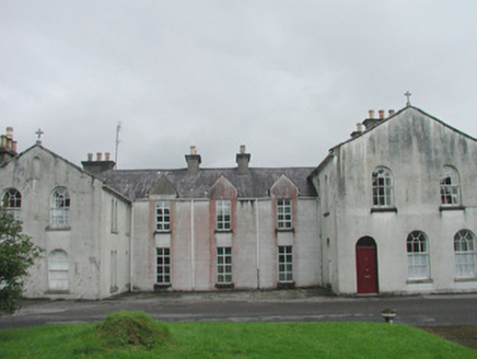 Banada Abbey ConventConvent/nunnery · 3.7 mi
 Banada Abbey ConventChurch/chapel · 3.7 miThe Turf Stack RockNamed rock · 4.0 mi
 Lough Talt TrailVisitor information · 4.2 mi
More archaeology and monuments in County Sligo · All of County Sligo
What do you know about this place?