What is recorded here
From the National Monuments Service (Archaeological Survey of Ireland) record CL016-052003
Places near here
Photo credits
- Night of the Big Wind, Wikimedia Commons · CC BY-SA 3.0 nl
- Andreas F. Borchert, Wikimedia Commons · CC BY-SA 4.0
- Martin Kerans, Geograph · CC BY-SA 2.0
- Joseph Mischyshyn, Wikimedia Commons · CC BY-SA 2.0
- National Inventory of Architectural Heritage
- Adrian King, Geograph · CC BY-SA 2.0
- Bob Jones, Geograph · CC BY-SA 2.0
- Colin Park, Geograph · CC BY-SA 2.0
- N Chadwick, Geograph · CC BY-SA 2.0
- Roger Diel, Geograph · CC BY-SA 2.0
- Joseph Mischyshyn, Geograph · CC BY-SA 2.0
 Cross in RoughanCross · 82 yd
Explorer Tom Lean against this fragment of a cross shaft from Roughan and wonder if it truly was part of the famous Tau cross nearby.
 CarnWedge tomb · 1.1 mi
Explorer Tom Up on Roughan Hill, this Carn sits proudly on exposed limestone pavement, offering you a spectacular sweep of views from the southeast to northwest.
 Leamaneh Castle (in ruins)Castle, tower house · 1.3 mi
Explorer Tom Five stories of limestone in Leamaneh North, where the missing garderobes make me wonder if 15th-century castle life was surprisingly low-key.
 Leamaneh CastleCastle · 1.3 mi
Explorer Tom Leamaneh Castle was built about 1480 as a basic multi-storied Irish tower house, later surrendered to Henry VIII.
 Kilinaboy Church (in ruins)Church · 1.3 mi
Explorer Tom Kilinaboy Church overlooks a shallow valley, built by or for Iníon Baoith, preserving its oblong shape beautifully.
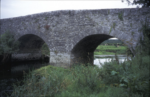 Poplar BridgeBridge · 1.4 mi
Explorer Tom Poplar Bridge in Crossard is a double-arch hump-back structure from about 1810, spanning the river with cut-stone voussoirs.
 Inchiquin IslandIslet · 2.1 mi
Explorer Tom Inchiquin Island! A small islet with a name that sounds like it could be part of a royal lineage, what secrets does it keep in County Clare?
 Rock IslandIsland · 2.2 mi
Explorer Tom Rock Island, with its rugged silhouette, stands proudly near Lough Inchiquin’s southern shore.
 Burren Centre KilfenoraVisitor information · 4.3 mi
Explorer Tom Burren Centre Kilfenora is a haven for those seeking the beauty of the Burren in County Clare
 High CrossHeritage attraction · 4.3 mi
Explorer Tom High Cross: an ancient landmark where faith and heritage stand tall in County Clare
 Cave of the Wild HorsesCave · 4.6 mi
Explorer Tom Cave of the Wild Horses sits six kilometers west of Carran, evoking images of untamed creatures in the dark.
 Poulnabrone - Burren GeositeVisitor information · 4.9 mi
Explorer Tom Poulnabrone - Burren Geosite has me thinking it's a place where the earth has a special shape; the account doesn't say what's special about it.
More archaeology and monuments in County Clare · All of County Clare

What do you know about this place?Tap to add a comment or ask a question