
Places near here
Photo credits
- National Inventory of Architectural Heritage
- JohnArmagh, Wikimedia Commons · CC BY-SA 3.0
- Pamela Norrington, Geograph · Creative Commons Attribution-ShareAlike 2.0
- Paul Cowan, Wikimedia Commons · CC BY-SA 2.0
- Mike Searle, Geograph · CC BY-SA 2.0
Explorer Tom Thorn Cave in Mayo is basically a goatee for geology, just all prickly and weird. A goat once ruled this spot with an iron hoof and demanded tribute in the form of clover. This is your ideal stop for a massive stretch and a yawn that could wake the dead.
 Kinaff BridgeBridge · 973 yd
Explorer Tom Kinaff Bridge would be the best man at a wedding. It stands there all night, holding things up so nobody falls over, but no one thanks it for the effort. Tell th nearest passerby that this bridge is doing all the heavy lifting in the village, literally.
 bridge1431 yd
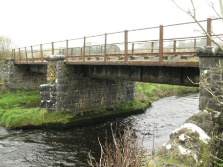
Explorer Tom Bridge in Ballinlag was built by London chaps who thought they knew everything about Mayo water. It’s got a serious face and a history tied to the Burma Road line. Leave nothing behind but your footprints on the path.
 Round Tower2.4 mi
Explorer Tom Round Tower in Meelick is sick of being asked if it’s actually round, because yes, mate, it’s circular, stop squinting at it from a distance. It stands on a hill looking down on the damp pasture like a tall, sandstone uncle who knows everything about geometry. Bring your nan, she'll know more than me.
I'll Send You The FareMemorial · 3.3 miExplorer Tom I'll Send You The Fare has a serious feud with the rain, getting wetter than any other memorial in the county because it stands out too proud. It’s dedicated to people who emigrated from Kiltimagh and Bohola in the 1950s, which is quite the journey for a sculpture to be thinking about. I bet it wishes it could send its own fare back to the dry side. Whisper a secret at it, it's kept worse.
Brabazon WoodsForest · 3.3 miExplorer Tom Brabazon Woods would tell you in a job interview that its main skill is standing still for centuries without complaining at all. It sits next to a historic estate, so it’s used to being looked down on by people with better hats. Visit, then text me what you think. I'll pretend to read it.
Kiltimagh MuseumMuseum · 3.4 miExplorer Tom Kiltimagh Museum has a matchmaker who works there and has paired off more locals than you can shake a stick at, according to local rumor. It’s a small museum with big stories, probably because everyone in town knows something interesting about the exhibits. I’d bet my last coin that the owner knows where all the hidden treasure is, but he won’t say. Find the date carved somewhere and feel clever.
Youth Memorial GardenMemorial · 3.4 miExplorer Tom Youth Memorial Garden: I’m pretty sure this garden has a family tree that’s mostly made up of wind and bad decisions by young men who thought they were invincible. It’s got a lovely, slightly melancholy vibe that makes you want to whisper your secrets to the bushes. The youth here is permanent, which is either comforting or terrifying depending on your mood. Go at sunset and thank me later.
 Grave YardGraveyard · 4.9 mi
Explorer Tom Graveyard in Toomore would order extra vinegar on its chips because it likes things sharp and memorable. It recently got a new shrine, which is basically a fancy hat for the entrance. If it's closed, admire it from the road like a polite stalker.
 Knock ShrineHeritage attraction · 7.7 mi
Explorer Tom I'll keep my big mouth quiet for the people praying at Knock. Knock Shrine grew from an evening that the people present never forgot. On 21 August 1879, Mary Byrne and other villagers said they saw figures at the church gable while the Mayo rain came down. Their accounts describe a still scene that lasted nearly two hours, with people gathering and praying; the witnesses also said the ground around the figures stayed dry. I am not going to tell you what they saw. Mayo rain rarely asks my permission, but the witnesses' account asks for careful listening. What I can tell you is that their words were taken down by a church inquiry that autumn, and a second inquiry in 1936 returned to surviving witnesses because many early papers were thought lost. The original wall attracted so many visitors that pieces were taken away as souvenirs. Today this is a living place of pilgrimage, so enter with care for the people who have come to pray. Whatever you believe, listen to how a wet evening changed a village's place in the world.
 CastleCastle, unclassified · 10 mi
Explorer Tom Castle on Island Lake hates when people ask if it’s haunted; it prefers ‘mysteriously absent’. It vanished so fast the locals just shrugged and built a house instead. Bring a flask of something warm and a story to swap.
 IndicatedHouse, fortified house · 10 mi
Explorer Tom House in Island is currently being judged by rabbits who think its gunloops are just fancy holes for them to hide in. They’re not wrong, actually. Get there early and have it all to yourself.
More archaeology and monuments in County Mayo · All of County Mayo

What do you know about this place?Tap to add a comment or ask a question