
Places near here
Photo credits
- National Inventory of Architectural Heritage
- Duncan Grant, Wikimedia Commons · CC BY-SA 2.0
- Aiden Clarke, Wikimedia Commons · CC BY-SA 2.0
- Mike Searle, Geograph · CC BY-SA 2.0
- Wikimedia Commons contributor · CC BY 2.5
 farm house1.9 mi
Explorer Tom Farm house in Ranagissaun is part of the domestic built heritage of Kilmovee. It has a rectilinear plan with a featureless doorcase, which means it doesn’t try too hard. The openings diminish slightly on each floor, creating a feint graduated visual impression that’s very understated. Just spot it from the road and admire how boring but sturdy it is!
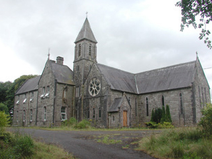 Saint Mary's ConventConvent/nunnery · 2.0 mi
Explorer Tom Saint Mary's Convent in Friarshill is a Gothic Revival beauty that nearly got famous for being haunted by a very polite ghost who only knocked on doors during tea time. The Sisters of Charity built it, and even though they’ve moved out, the stained glass still looks like it’s judging your outfit choice. Ide
 CashelFairy fort / stone ringfort · 2.5 mi
Explorer Tom Another cashel in Kilcashel stands tall on the ridge, looking down its nose at everyone else with its thick, sturdy drystone walls. The builder was definitely thinking about views when they stacked those rocks, ignoring the wind and the cold completely. Bring biscuits, every good story needs biscuits.
Bockagh HillMountain / peak · 4.1 miExplorer Tom Bockagh Hill bragged about surviving a storm so bad it made the clouds cry and quit their jobs for a while. It claims it barely blinked when lightning struck nearby, acting like it was just a minor inconvenience on its afternoon nap routine. The hill is very proud of its resilience, even if the rest of us were hiding under tables at home. Ideal spot for a dramatic phone call.
Druminagh WoodForest · 5.0 miExplorer Tom Druminagh Wood in County Roscommon has been hiding a scandal involving a very confused goat that wandered in and never quite left the premises entirely. It’s keeping the secret tight, mostly because it doesn't know how to explain the situation properly yet. Leave nothing but footprints and a bad pun.
 ToberaraghtHoly well · 6.1 mi
Explorer Tom Toberaraght in Clogher has cursing stones cemented on top like very angry bookmarks. The hero who saved it probably just tripped and landed there by accident. Grand place for a sulk or a snog, entirely your call.
Bawn IslandIslet · 7.7 miExplorer Tom Bawn Island started because two lads in the pub bet fifty quid they could name it and get away with it. They lost badly, but the name stuck because nobody else wanted to deal with the paperwork. Go back in winter, it’s a completely different animal.
Rose PointHeadland · 8.5 miExplorer Tom Rose Point in County Sligo had the whole parish arguing about it last Tuesday, mostly over who owned the view. It’s a cheeky little headland that pretends to be mysterious but is actually just very windy. A good place to forget your phone for ten minutes and enjoy the silence.
Square WoodForest · 8.7 miExplorer Tom Square Wood in County Roscommon looks like it was drawn with a ruler and some very angry geometry chalk. Rumor has it a fox took charge last spring and forced everyone to walk in perfect parallel lines. Bring someone who'll believe anything.
 CastleCastle, unclassified · 9.8 mi
Explorer Tom Castle on Island Lake hates when people ask if it’s haunted; it prefers ‘mysteriously absent’. It vanished so fast the locals just shrugged and built a house instead. Bring a flask of something warm and a story to swap.
 IndicatedHouse, fortified house · 9.8 mi
Explorer Tom House in Island is currently being judged by rabbits who think its gunloops are just fancy holes for them to hide in. They’re not wrong, actually. Get there early and have it all to yourself.
 Curlew MountainsMountain / peak · 12 mi
Explorer Tom The Curlew Mountains may have nothing to do with curlew birds, which is awkward because I had prepared a terrific imitation. Their name likely grew from Irish words for rugged, pointed hills. Between Boyle and Castlebaldwin, hard sandstone and conglomerate rise above softer limestone country, giving this modest range its shape. The Battle of Curlew Pass took place here in 1599, a serious chapter that deserves a straight account. I would leave the bird call out of that story and use it only to annoy my travelling companion afterwards. Choose a lawful public trail or viewpoint, check local routes and weather, and treat any historic ground respectfully. Look at the ridgeline against the lower land. You can see why even these relatively low hills have long mattered.
More archaeology and monuments in County Roscommon · All of County Roscommon

What do you know about this place?Tap to add a comment or ask a question